
Northern Red Sea · Strait of Gubal
Strait of Gubal Where the Gulf of Suez meets the Red Sea
Firstly, every ship leaving Suez has to pass through the Strait of Gubal, and for a century and a half a great many of them failed to. Consequently this stretch of water holds more wrecks than any comparable piece of the Egyptian coast, along with two enormous reefs, a pair of tidal channels and a lagoon that stays workable when the open sea does not.
How the Strait of Gubal is laid out
Firstly, the strait joins the Gulf of Suez to the open Red Sea, bounded to the west by the Egyptian mainland and to the east by Sinai. Because the Gulf of Suez has a different geological origin from the Gulf of Aqaba, it is far shallower, averaging only about eighty metres. That difference shapes everything else here.
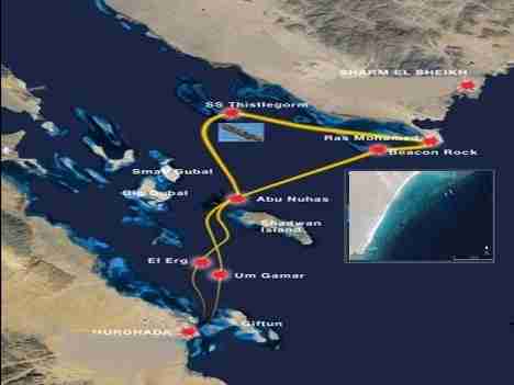
Notably, the shipping channel is much wider than the Strait of Tiran. To the northeast it is flanked by two outcrops, Beacon Rock and Shag Rock, each carrying a beacon and, beneath it, a wreck: the Dunraven at the first, the Kingston at the second. Meanwhile the southwestern edge is marked by the southern tip of Shadwan Island, whose light stands 15.2 miles from the one on Beacon Rock.
Meanwhile, two vast flat coral formations dominate the southeastern section, the kind Arabic calls shaab. Indeed, between them they enclose shallow, sandy-floored lagoons, and those lagoons are the reason safari boats can work this area in weather that closes everything else.
Why so many wrecks
- First, the Strait of Gubal narrows exactly where captains start to relax
- Then the reefs sit flat and barely break the surface
- Also, two days out of Suez, the worst of the passage feels behind you
- Meanwhile the northerly current pushes vessels onto the eastern reefs
- Consequently the Strait of Gubal collected wrecks for a century and a half
- Finally, radar reflectors and solar lights changed all that
Two big names sit just outside this page. The Thistlegorm lies on the eastern side of Sha’ab Ali, and the Rosalie Moller beyond Big Gubal. Overall, both have their own write-ups; everything below covers the rest of the strait.
Jump to a site
Inside the reefs: Sha’ab Mahmud and Sha’ab Ali
Sha’ab Mahmud runs in line with the western side of the Ras Mohammed peninsula, about six miles long and 2.7 wide, oriented northwest to southeast, with Beacon Rock at its southern point. Consequently, behind it lies a wide lagoon that swell never really reaches. Specifically, its southern entrance is marked by Beacon Rock to the west and by the reef of Sha’ab el-Utat to the east.
Specifically, two passages break the reef. Small Crack is only workable for small boats, whereas Big Crack, at 27°46.540′ N and 34°03.362′ E, is navigable. Further north sits a roughly circular reef the local fishermen call Sha’ab en-Neghs.
Meanwhile, Sha’ab Ali lies north of Sha’ab Mahmud and stretches 8.3 miles on a northeast–southwest line, separated from the Sinai coast by a channel averaging twenty to twenty-five metres. Notably, its lagoon runs seven to ten metres deep, with an entrance on the northeastern side marked by lit buoys. Usually, safari boats moor inside overnight, so that divers reach the Thistlegorm at dawn rather than sharing it with the day boats from Sharm and Hurghada.
The lagoons are the point. When the open sea is unworkable, the sheltered water behind these reefs still is. Consequently the Strait of Gubal often saves a safari itinerary rather than merely featuring in one.
Sheltered diving in the Strait of Gubal
Altogether four Strait of Gubal sites sit inside or beside the lagoon system. None of them is technically demanding, yet each rewards a slow dive, and together they are what makes this area dependable in bad weather.
Alternatives, the Seven Pinnacles
Latitude to be confirmed · 34°11.903′ E
Firstly, three miles west of Ras Mohammed a line of coral pinnacles runs east to west for about a mile and a half along the southern edge of Sha’ab el-Utat, flanking a large sandy lagoon roughly ten metres deep. Notably, local fishermen call it Saba Erg, the Seven Pinnacles. Divers renamed it Alternatives, because when the open sea is impossible this is the alternative.
Usually, the classic dive circles the two middle pinnacles, which line up with a fixed mooring. Above all, visibility here depends almost entirely on the tide. Specifically, a current out of the south makes it poor, especially with wind and swell behind it. Conversely, in calm water with no current or a northerly one, the site is thick with life: numerous coral genera, big groupers (Epinephelus malabaricus and E. tauvina), bluespotted stingrays, squid, nudibranchs and even leopard sharks (Stegostoma fasciatum).
Watch for
- Check the current direction first, since it decides the visibility
- Also skip it when the sea is rough and the water is milky
- Night dives only in optimal conditions, and then with two torches

Stingray Station
27°43.845′ N · 34°11.241′ E
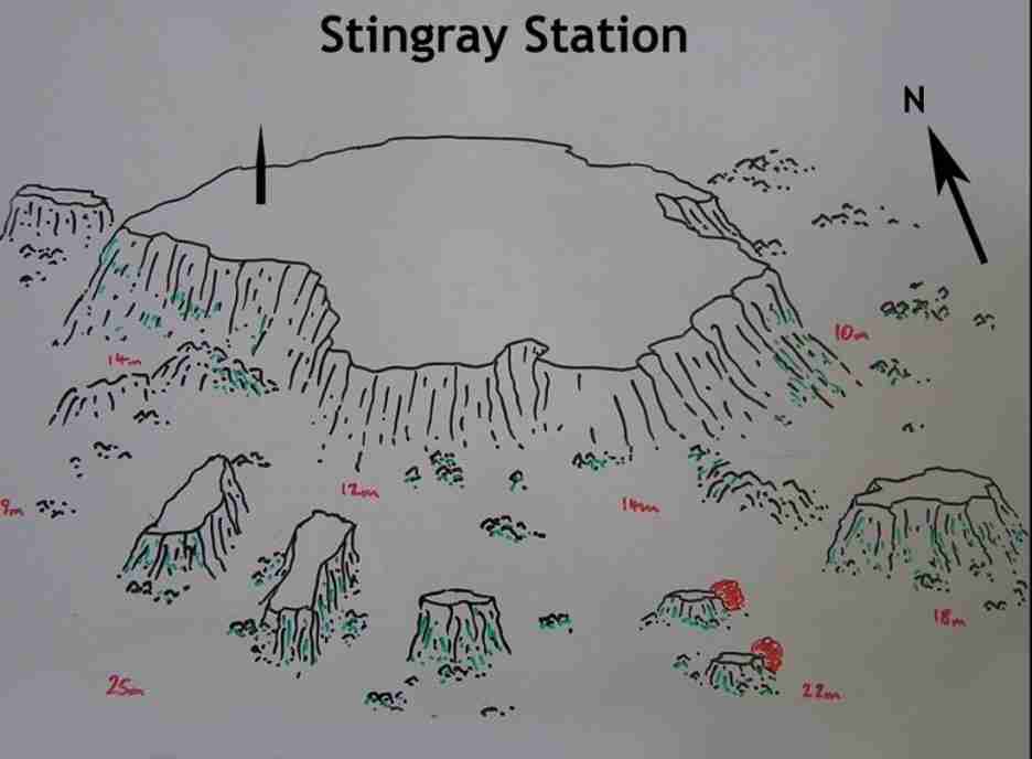
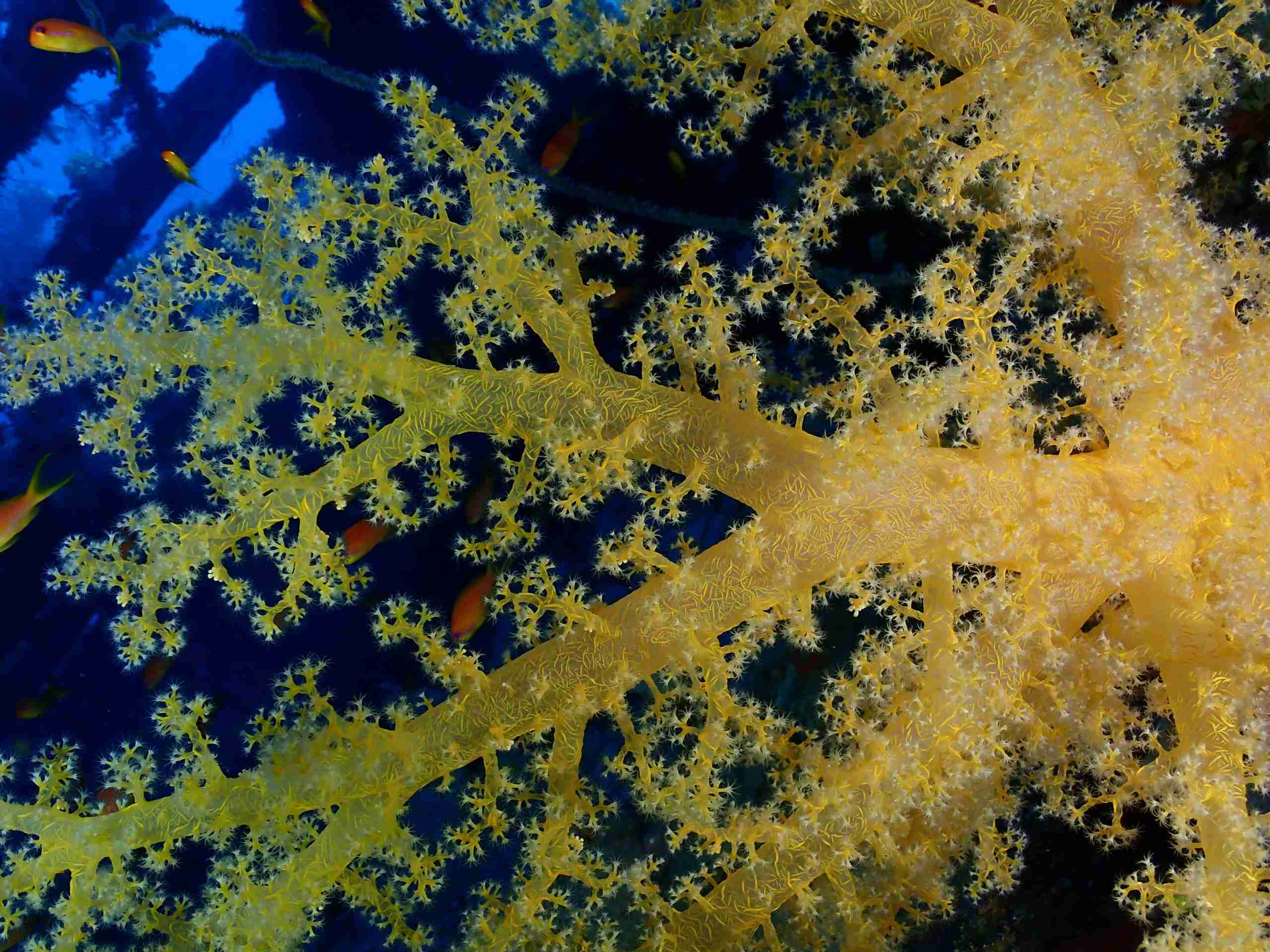
Meanwhile, in the northwestern part of Alternatives stands a large, roughly quadrangular outcrop. Indeed, its name is entirely descriptive: bluespotted stingrays gather here in numbers, particularly through the spring months. Besides, anthias swarm around the red Alcyonarians and red sponges along the northeastern ridge.
Lonely Mushroom
27°43.640′ N · 34°09.293′ E
Further, about 1.7 miles west of Stingray Station a single large circular tower rises from the sand. Notably, a shamandura is fixed to the reef at the surface, although it can be surprisingly hard to spot. Overall, despite its small size the site makes a good short dive, above all for macro photographers: nudibranchs and shrimps hide between the soft corals and the small hard heads.
Small Crack
27°43.884′ N · 34°05.894′ E
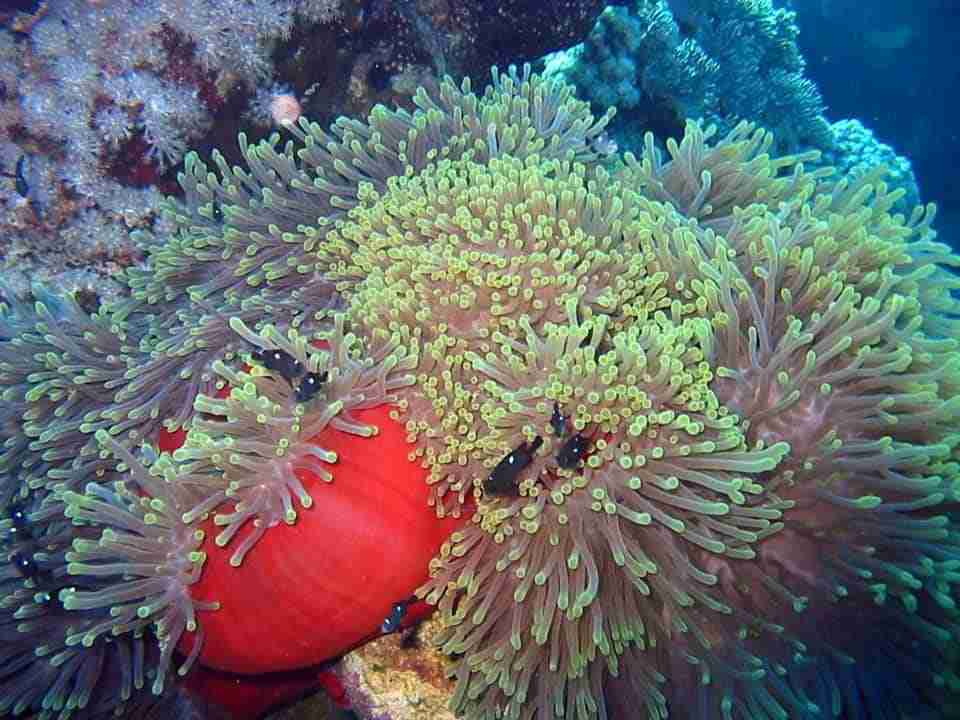
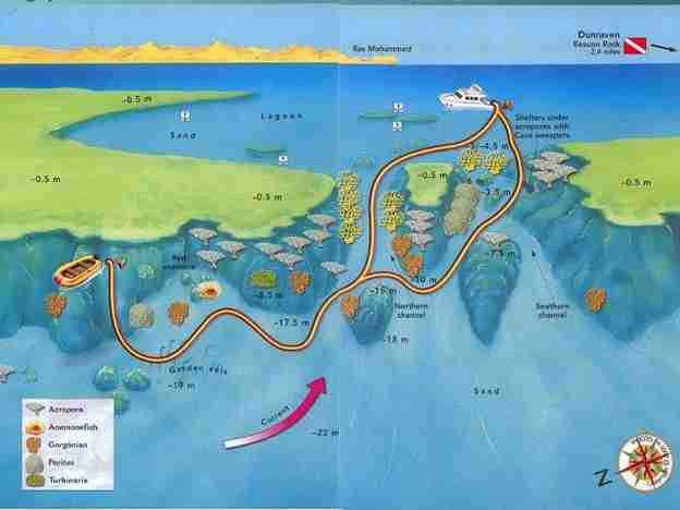
Sha’ab Mahmud is breached by two channels, and Small Crack is the most demanding dive in the Strait of Gubal. Known to local fishermen as Fossma Saghir, it is the more southerly of the two. Specifically, a large coral formation splits its central body into two secondary channels between five and eight metres deep, where the tidal current can become extremely strong.
Above all, direction matters more than anything else here. Namely, on a flooding tide the current runs north and pushes you out of the lagoon towards the open sea; on an ebbing tide it runs south, back towards the lagoon. Therefore diving the ebb lets you drift home to a boat moored inside. Using a zodiac makes the whole thing easier.
Meanwhile, the outer reef wall drops to a sandy floor between eighteen and twenty-two metres, carrying gorgonians, Alcyonarians and large table corals. Notably, turtles are common, as are leopard sharks and whitetip reef sharks. Likewise, in summer schools of barracuda and jackfish arrive, with a school of breams (Acanthopagrus sp.) near the mouth of the channel. Inside the northern channel, fire coral (Millepora dichotoma) dominates, as it usually does where the water moves hardest.
Watch for
- Check the current before entering, every single time
- Then, if it runs hard to the north, do not dive without a zodiac
- Also the fire coral in the northern channel, which is unforgiving
The wrecks of the Strait of Gubal
Altogether, four of them are covered below, from a Victorian steamer lying upside down to a barge nobody can positively identify. Above all, each one sits shallow enough for a recreational dive, which is unusual for wrecks of this age.
The Dunraven at Beacon Rock
27°42.200′ N · 34°07.300′ E · 15–29.5 m
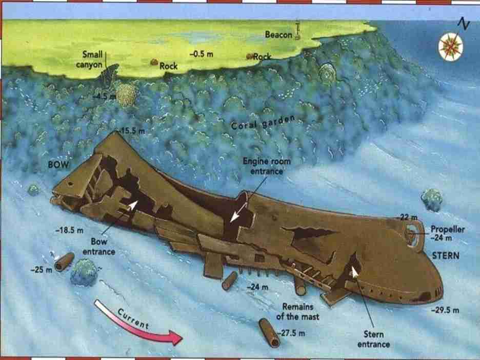
Firstly, a small metal beacon marks the southern tip of Sha’ab Mahmud, 6.9 miles west of Ras Mohammed. Beneath it lies the best known wreck in the Strait of Gubal, the British merchantman Dunraven, built at Newcastle in 1873 by Mitchell & Co with mixed sail and steam propulsion and bound for Bombay when she was lost in 1876. She stayed hidden until 1977, when the geologist Arye Keller and the underwater cameraman Howard Rosenstein found her, and a BBC documentary in 1979 made her famous.
Today, she lies upside down in two sections between fifteen and 29.5 metres. Consequently, because her cargo of timber and cotton bales burned and was lost in the wreck, the hull is essentially a large empty cave, entered through three main openings at stern, centre and bow. Normally, reach her by zodiac with the boat moored in the shelter behind the lighthouse.
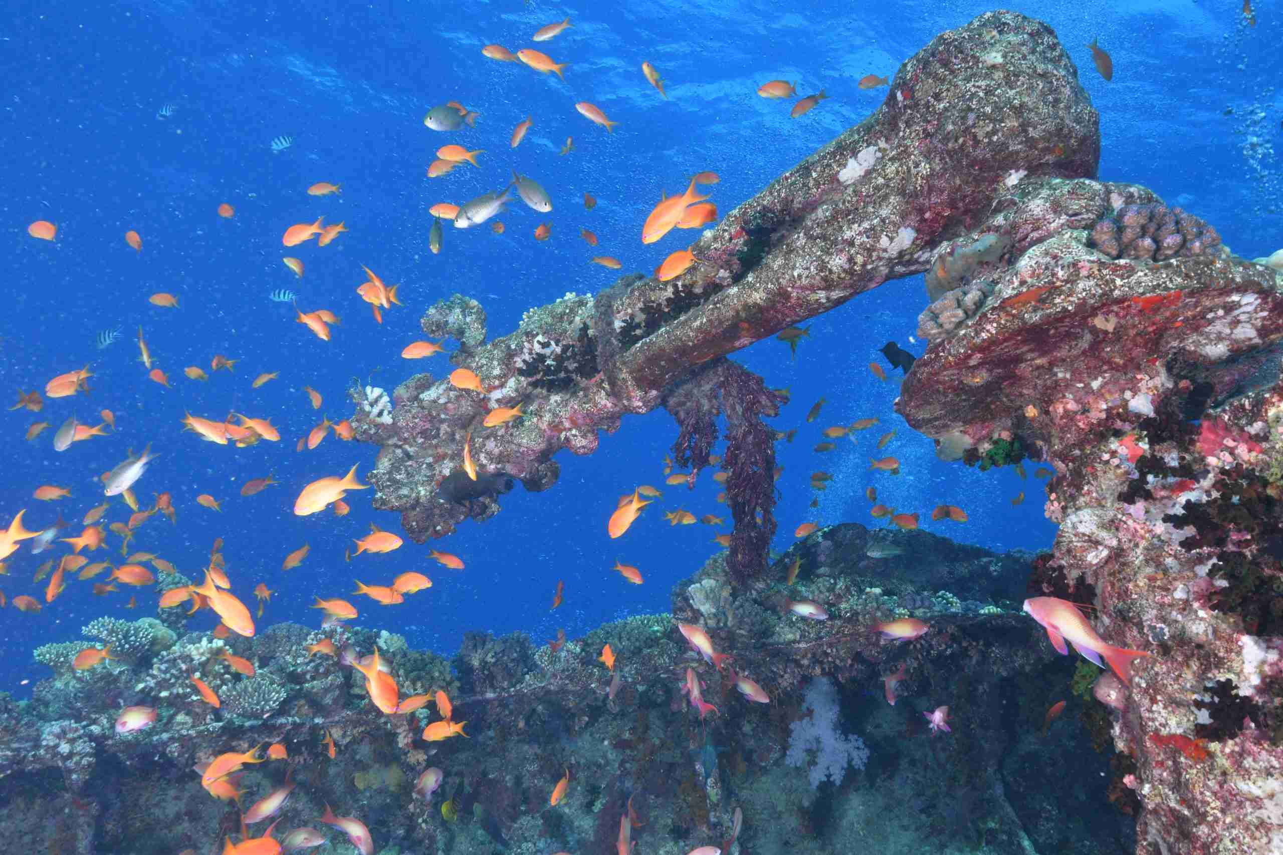
Next, start at the stern, the deepest point, and after a few dozen metres you can go inside, into a space held by big groupers, lionfish, swarms of glassfish and multicoloured Alcyonarians. Exit amidships by the engine room, then work the outside of the bow and the coral garden beyond it, which is virtually intact.
| Type | Steamer, British |
| Built | 1873, Mitchell & Co, Newcastle |
| Dimensions | 85 m × 9.7 m, about 1,800 t |
| Lost | 1876, bound for Bombay |
| Depth | 15–29.5 m |
Watch for
- Dive it in calm weather and settled conditions only
- Also a current that often runs to the north
- Then carry a torch, even when the visibility looks generous
- Far less crowded than the Thistlegorm, which is half the appeal
Shag Rock and the Kingston
27°46.438′ N · 33°52.241′ E · 4–17 m
Firstly, Shag Rock sits at the northern edge of the Strait of Gubal, a shallow reef south of Sha’ab Ali, six miles from the Thistlegorm, marked by a small metal lighthouse on its southeastern side. Besides, a big sandy plateau beside the light runs to eight or ten metres and carries a fixed shamandura known as the Lady Jenny Mooring.
Meanwhile, on the northern side, at fifteen metres, a small wreck lies south to north with her bow stranded on the reef. Notably, for years she was wrongly called the Sara H., a name that belongs to no real ship. She is in fact the British cargo vessel Kingston, built in 1871 at Sunderland by the Oswald Shipbuilding Co, which ran aground here on 22 February 1881 carrying coal for Aden.
First, begin at the stern at fifteen metres, where the propeller is still intact, then work into the hull. Since the wooden bridge has gone, the interior is open and well lit, and the boilers and engine room remain clearly readable. Unfortunately, the bow, at four metres, is destroyed. Besides, to the right of the wreck the mast lies on the seabed. Afterwards continue east or west along the reef for jackfish, groupers, snappers, turtles, whitetip reef sharks and the occasional eagle ray. Overall, dolphins are seen regularly in this area.
| Type | Merchant, British |
| Built | 1871, Oswald Shipbuilding Co, Sunderland |
| Dimensions | 78 m × 10 m, 1,449 t |
| Lost | 22 February 1881, bound for Aden with coal |
| Depth | 4–17 m |
The Ulysses at Gobal Seghir
27°41′12″ N · 33°48′10″ E
Firstly, Little Gobal sits at the very end of the shipping lane, where the northwestern Red Sea narrows into the Gulf of Suez. Naturally, approaching from the north, a master two days out of Suez tends to assume the difficult water is behind him. Certainly, in August 1887 Captain Arthur Bremner assumed exactly that.
Consequently, his ship struck the reef in the early hours of the 16th. Initially the damage seemed slight and the pumps coped, so Bremner waited for a passing vessel rather than lightening the load. The steamer Kerbela carried word to Suez, and on the 18th The Times reported that the Ulysses was ashore at Jubal Island and leaking a little. Meanwhile, unseen, the loaded hull was pivoting on a coral head and steadily weakening.
Eventually, help arrived on the 20th, by which time she was down by the stern. Lighters and labourers came from Suez, and HMS Falcon lent crew to unload in the August heat, wading and swimming through foul water in the holds, hauling cargo over the reef and a third of a mile to the lighters. Nothing was enough. All parties left on 6 September, bad weather finished her, and no date was ever recorded for the moment she finally went under. The loss was put down to navigational error, though the fault was never established. Bremner never went to sea again.
Diving the Ulysses
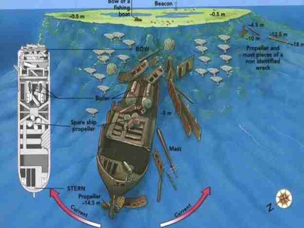
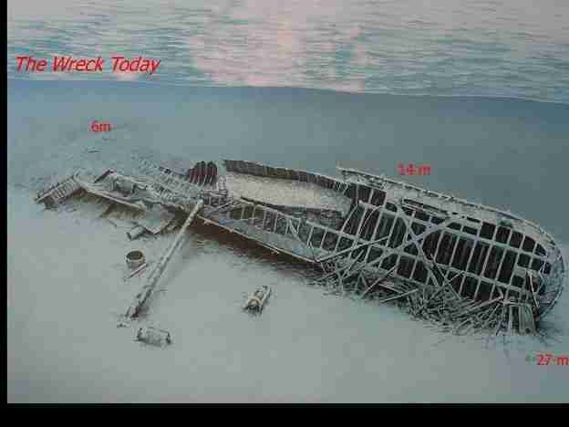
Today, she lies up the reef, stern deep and bows in very shallow water, now over on her port side with most of the decking rotted away to leave a framework of iron girders not unlike the Carnatic’s. Currents can be severe here, so getting down into the shelter of the wreck early is the sensible move.
Above all, the stern is the most photogenic part, with the rounded lines of the period, the rudder and propeller still in place, and bollards, winches and railings above. Because the vessel is wide open and lit throughout, both internal deck levels can be explored with almost no risk of losing your way. Meanwhile, amidships, some evidence of the small wheelhouse survives below where the funnel stood, with masts and spars scattered on the seabed. Further forward she is well broken up, in separate structures running all the way into the shallows, and those larger sections hold thousands of Vanikoro sweepers.
| Type | Iron screw steamer, planked; British |
| Built | Launched 1871, Leslie & Co, Newcastle |
| Dimensions | 95.1 m × 10.2 m, draught 7.7 m |
| Tonnage | 1,992 gross, 1,843 net |
| Engine | Two-cylinder steam, 225 HP, P Stephenson & Co |
| Lost | 16 August 1887, bound for Penang |
Depth figures disagree. The main guide puts the stern at 27 m, while two other accounts describe the wreck sloping to 15 m and to 25 m. Treat 27 m as the deepest point until you have confirmed it, and plan the dive around the shallower structure rather than the number.
The Gubal Barge at Bluff Point
Bluff Point, Gubal Island · 8–14 m
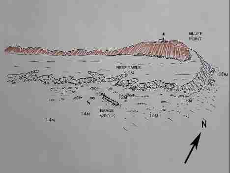
Bluff Point takes its name from the turbulence that strong currents create against the eastern wall of the island, and it is where safari boats wait before crossing the strait. Consequently it gets busy, and once boats are moored they tend to stay put.
Meanwhile, south of the lighthouse lies the Barge, and it makes one of the better night dives in the northern Red Sea. Specifically, her skeleton shelters an unusual concentration of nocturnal life: giant, peppered, yellow-mouth and yellow-margin morays, crabs, shrimps, nudibranchs, cardinalfish and octopus, with jacks, Napoleon wrasse and turtles by day. Overall, there is little or no current on the mooring, and 14 metres is as deep as it gets.
Officially, nobody is certain what she was. Probably Egyptian, possibly a patrol boat, somewhere between twenty and thirty metres long, sunk in 1967. Equally, alternatively she may have been a barge from the Ulysses salvage operation, or a gunboat lost in the Six-Day War. Most likely the question stays open.
Watch for
- Stonefish, scorpionfish, crocodilefish and lionfish, especially at night
- Also the sandy plateaus at 18 and 26 metres, and a small cave
- Then the blue, since eagle rays and dolphins pass through
- Likewise, Big Gubal, ten minutes southwest, has a sloping wall and an eel garden near 22 m
Choosing a dive in the Strait of Gubal
In short, the table below groups the Strait of Gubal sites by level rather than by position. Notably, the number in the first column matches the index above, so you can jump back to any write-up.
| # | Site | Entry | Level | Why go |
|---|---|---|---|---|
| 2 | Stingray Station | Mooring | Beginner | Bluespotted stingrays gather in spring |
| 8 | The Gubal Barge | Mooring | All levels | The best night dive in the strait |
| 3 | Lonely Mushroom | Mooring | Beginner | A short macro dive on a single tower |
| 6 | Shag Rock, Kingston | Mooring | All levels | A shallow, open, well-lit wreck |
| 1 | Alternatives | Mooring | All levels | The bad-weather option, and leopard sharks |
| 5 | Dunraven | Zodiac | Intermediate | An upturned hull you can swim through |
| 7 | The Ulysses | Zodiac | Intermediate | An 1887 steamer, open and photogenic |
| 4 | Small Crack | Drift | Intermediate | A tidal channel with sharks and barracuda |
Planning a day of Strait of Gubal diving
Practical notes
- First, check the tide, because it decides both the current and the visibility
- Then remember the set is usually north to south, and it can run hard
- Also carry a torch on every wreck, even in bright water
- Equally, two torches for any night dive, without exception
- Meanwhile a zodiac turns Small Crack, Dunraven and the Ulysses from awkward into easy
- Consequently the lagoons stay workable when the open sea does not
- Finally, moor early at Bluff Point, since it fills up by evening
The current is the real hazard here, not the depth. Specifically, around the corner from Bluff Point the north-to-south flow can be severe, and Small Crack on a flood tide will push you out to open sea. Neither is a place to improvise.
Useful links
- Ras Mohammed National Park — the walls, chimneys and caves across the peninsula.
- Shark and Yolanda Reef — the classic drift at the southern tip.
- Local reefs around Naama Bay — eighteen sites, twenty minutes from the marina.
- Safety standards and emergency care — briefings, oxygen and chamber contacts.
- Red Sea Liveaboard — safari routes and boats across the Egyptian Red Sea.
- Divers Alert Network (DAN) — insurance and emergency guidance.
Frequently asked questions
Why are there so many wrecks here?
Because the channel narrows exactly where masters coming down from Suez start to relax, and the reefs sit flat and barely break the surface. Ultimately, modern lights and radar reflectors ended the pattern.
Which wreck suits a less experienced diver?
The Kingston at Shag Rock. Namely, it sits between four and seventeen metres, the interior is open and well lit, and there is a fixed mooring beside it.
Is the Thistlegorm covered on this page?
No. Instead, she lies on the eastern side of Sha’ab Ali and has her own write-up, as does the Rosalie Moller beyond Big Gubal.
What can be dived when the sea is rough?
Alternatives, Stingray Station and Lonely Mushroom, all of which sit behind the reef system. That shelter is exactly why divers renamed the first of them.
When should Small Crack be dived?
Specifically, on an ebbing tide, when the current runs south and carries you back towards a boat moored inside the lagoon. On a strong flood it pushes you out to sea instead. That is the one rule the Strait of Gubal never bends on.
What actually is the Gubal Barge?
Nobody knows. She remains one of the unsolved puzzles of the Strait of Gubal: probably Egyptian, possibly a patrol boat, sunk in 1967, and perhaps a barge left from the Ulysses salvage. The question has never been settled.
What are you waiting for?
Book your adventure
Tell us which experience you want to enjoy and leave the rest to us. If you have questions, or you are still choosing between routes, our team will talk it through with you before you commit to anything.
Inquiry