
Southern Sinai · Ras Mohammed diving
Ras Mohammed National Park Seven sites where the two gulfs meet
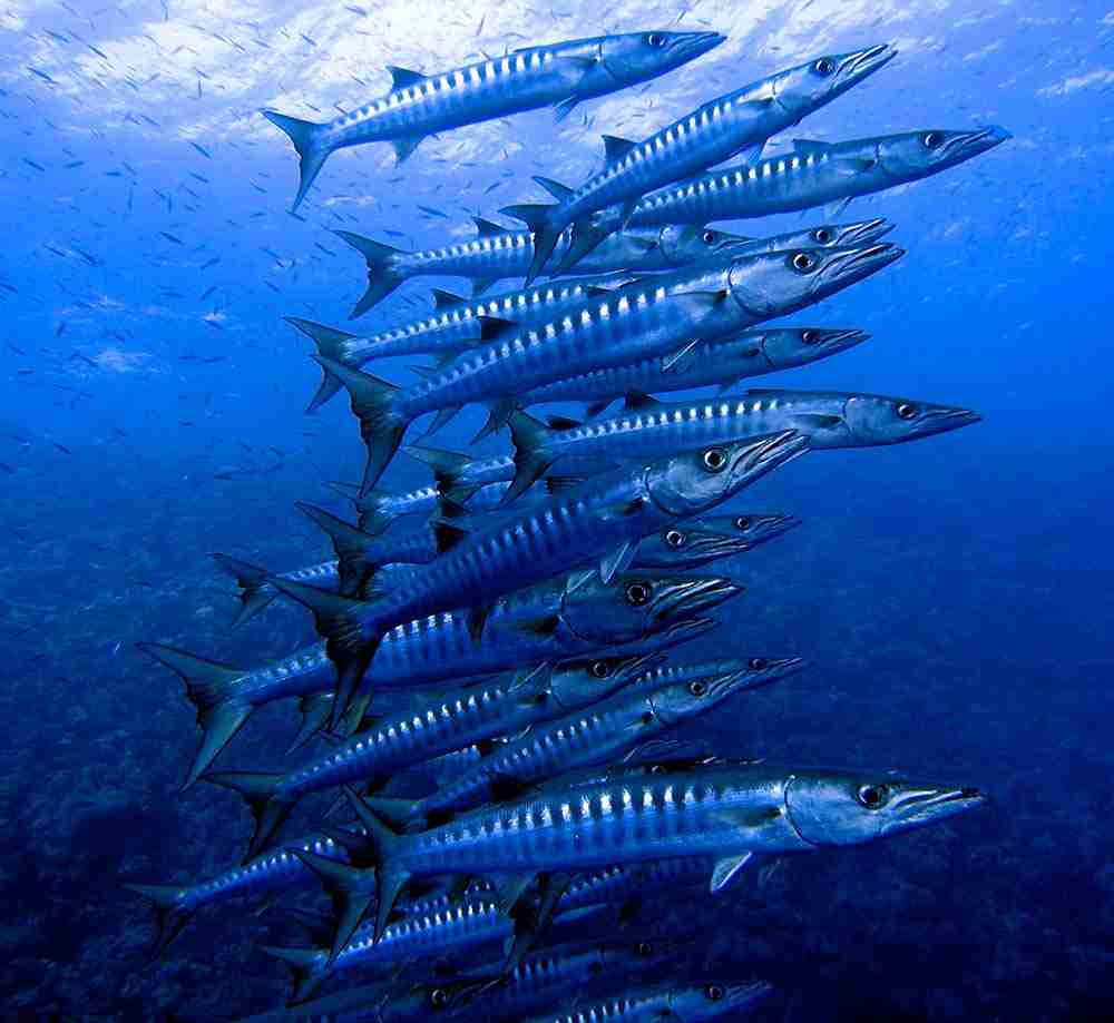
Ras Mohammed diving works because of geography. The peninsula pushes almost five miles into the sea and splits the Gulf of Aqaba from the Gulf of Suez, so every tide drives water hard around its tip. Consequently the corals feed, the reef fish feed on them, and the barracuda, jackfish, tuna and sharks arrive behind the crowd.
Where Ras Mohammed diving happens
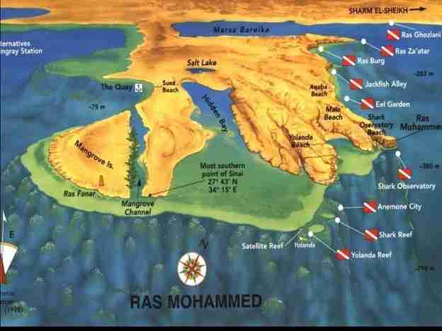
Leaving Sharm el-Sheikh the coast runs empty for more than a mile, with nowhere to shelter, until it reaches the small bay of Marsa Ghozlani. That is where Ras Mohammed diving properly begins. Then, beyond it opens Marsa Bareika, far larger and deeper, cutting 2.8 miles inland and shaping the peninsula itself.
Meanwhile, on the eastern side a wall of fossil coral runs almost unbroken, interrupted for a few dozen metres by Aqaba Beach, the only landing in the area. Finally it ends at the headland the Arabs named Mohammed’s Cape, because the profile of the rock resembles a bearded face. Notably, that spur stands about sixty metres high, and the Shark Observatory balcony sits on top of it.
Meanwhile the southern shore carries three beaches, Shark Observatory, Main and Yolanda, together with the shallow Hidden Bay whose mouth is nearly sealed by a long reef. The western side is low and sandy instead, and it holds the only sheltered mooring in the area, beside the half-drowned remains of an old jetty known as The Quay.
What the current does
- First, the narrowing peninsula accelerates every tidal stream
- Then that stream carries plankton and nutrients past the reefs
- Consequently hard and soft corals grow at an extraordinary rate
- Also the reef fish gather in numbers you rarely see elsewhere
- Meanwhile barracuda, jackfish and tuna work the edge of the blue
- Finally the sharks arrive, particularly between June and August
Mangroves matter here too. A shallow channel on the western side forms Mangrove Island, marked by a small beacon. Avicennia marina is rare in Sinai, and its root system filters nutrients straight from seawater, pushing the salt back out through the leaves as crystals.
Jump to a site
The national park behind the Ras Mohammed diving
Ras Mohammed is the southernmost promontory of Sinai, and its rock is old coral rather than ordinary stone. Indeed the most ancient of it dates to the Pleistocene, between 1.8 million and ten thousand years ago, which makes the whole headland a record of how far the sea has risen and fallen.
Because desert plain, dune, wadi, mountain, reef and mangrove all meet in one small area, the ecological count is unusual: 218 coral species, over a thousand fish, eighty plants, 220 birds and fourteen mammals. Similarly, in autumn the migration arrives as well, and white storks (Ciconia ciconia) break their journey here on the way from Europe to southern Africa.
Egypt made this its first national park in 1983, covering 97 square kilometres. Subsequently, in 1988, the northern coast of Sharm el-Sheikh and the islands of Tiran and Sanafir were annexed, bringing the total to 480. Overall, water dominates that figure: 365 square kilometres of sea against 115 of land, or 76% marine.
Visiting numbers
- Generally, roughly 150,000 visitors reach the park each year
- However, only a tenth of the territory is open to the public
- Also, the rest stays closed for conservation, not for convenience
- At least 100,000 of those visitors arrive by sea rather than road
Park rules are enforced. Certainly the fees, the briefings and the closed zones can feel heavy-handed, yet they are the reason the coral here still looks the way it does. Consequently, nothing is collected, nothing is touched, and no boat anchors outside a fixed mooring.
Ras Mohammed diving around Marsa Bareika
Two of the finest Ras Mohammed diving sites face each other across the mouth of the big bay, and a third sits just below them. All three are drifts along a wall, and all three reward divers who hold their depth rather than chase it.
Ras Ghozlani
27°47.527′ N · 34°15.752′ E
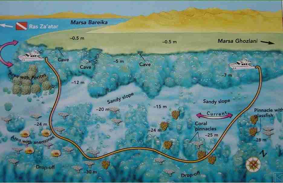
Marsa Bareika has Ras Ghozlani on its northern tip and Ras Za’atar to the south. Notably, divers were only let into the bay a few years ago, and access is still limited to the outer sides. Besides, a small stake on the sandy shore carries two banners, one red and one green, marking the zone nobody may enter.
Two fixed moorings used to sit on the accessible stretch, but they were removed, so today this is a drift. Instead, the route follows a broad sandy slope that starts at six metres and runs down to a drop-off between twenty-five and thirty. Moreover, coral pinnacles rise from that sand, most of them crusted in red and pink soft coral and swarming with anthias, alongside huge Acropora tables and branching heads. Indeed, near the entrance to the bay the effect is less like a reef than a forest.
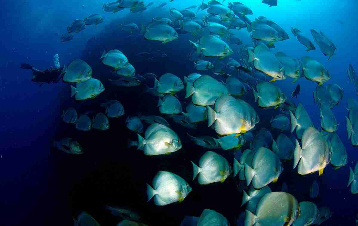
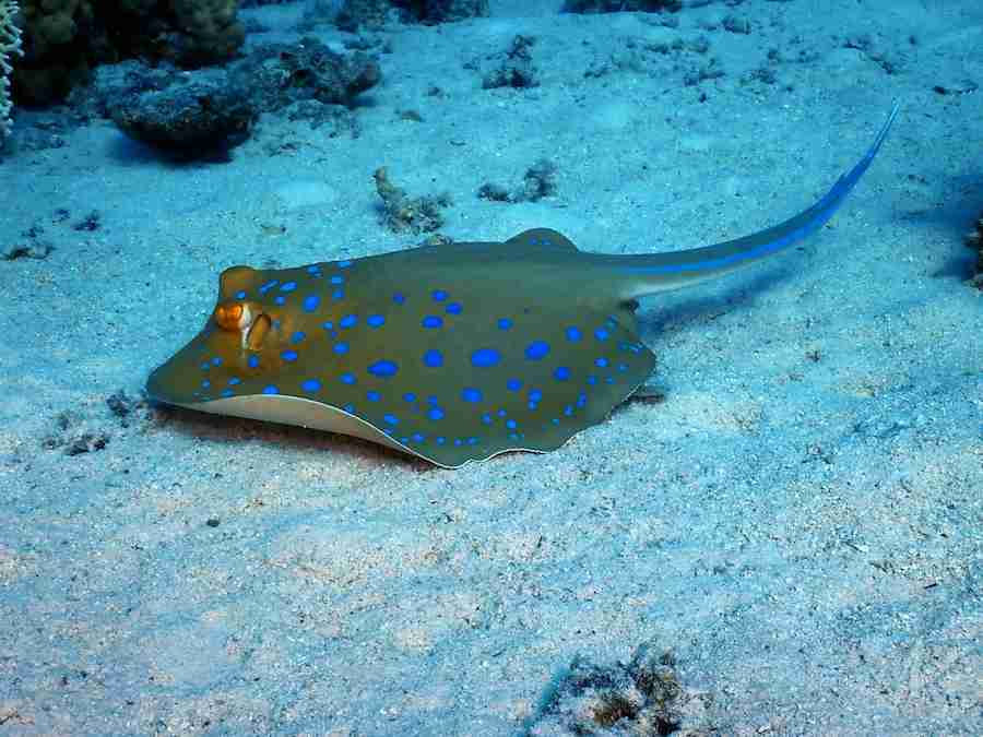
Notably, under the table corals you find batfish (Platax sp.), glassfish and groupers. Meanwhile the open sand holds bluespotted stingrays, pufferfish of the genera Arothron and Diodon, and triggerfish of the genera Odonus and Pseudobalistes.
Watch for
- Afternoon light, which throws the pinnacles and the hard coral into relief
- Also the crowds, because the site’s reputation has spread quickly
- Current is rarely strong here, though it usually sets north to south
Ras Za’atar
27°45.860′ N · 34°15.364′ E
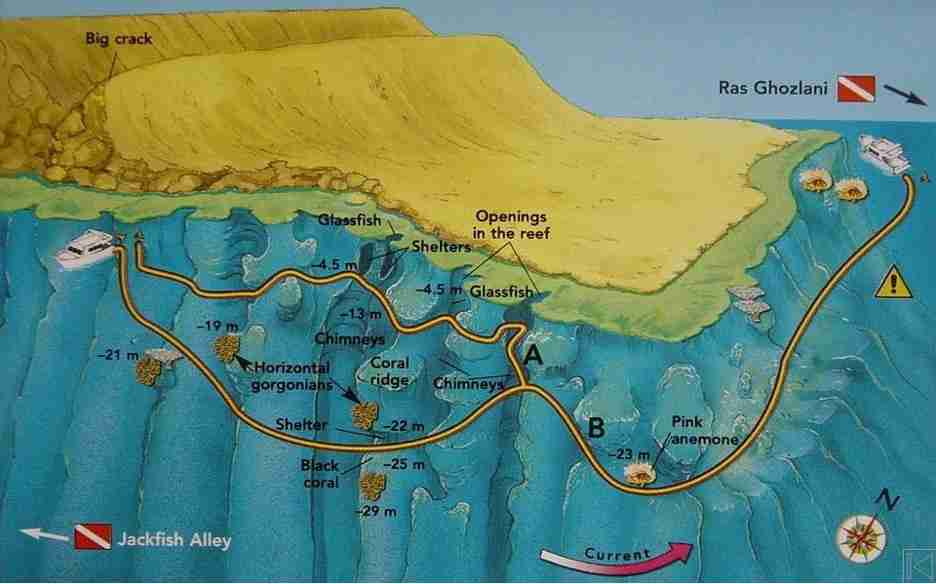
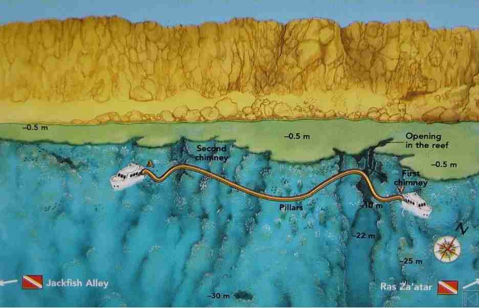
Firstly, this is the rocky promontory that closes Marsa Bareika to the south. Since there is no shamandura, the dive is a drift around the headland, and it can run either way depending on the water. Most often it goes northeast with the reef on your left. Because the best of it lies around the point, start past the large crevice you can see from the boat in the coastline.
First, the dive opens at a coral pinnacle carrying a table coral at twenty-one metres, then follows a wall that falls away vertically, painted with Alcyonarians and gorgonians set at a curiously horizontal angle, together with colonies of black coral (Antipathes dichotoma). Afterwards, come up to ten or fifteen metres rather than staying deep. That is where the chimneys begin, narrowing as they rise until they open onto the reef platform, and the sunlight pours down them.
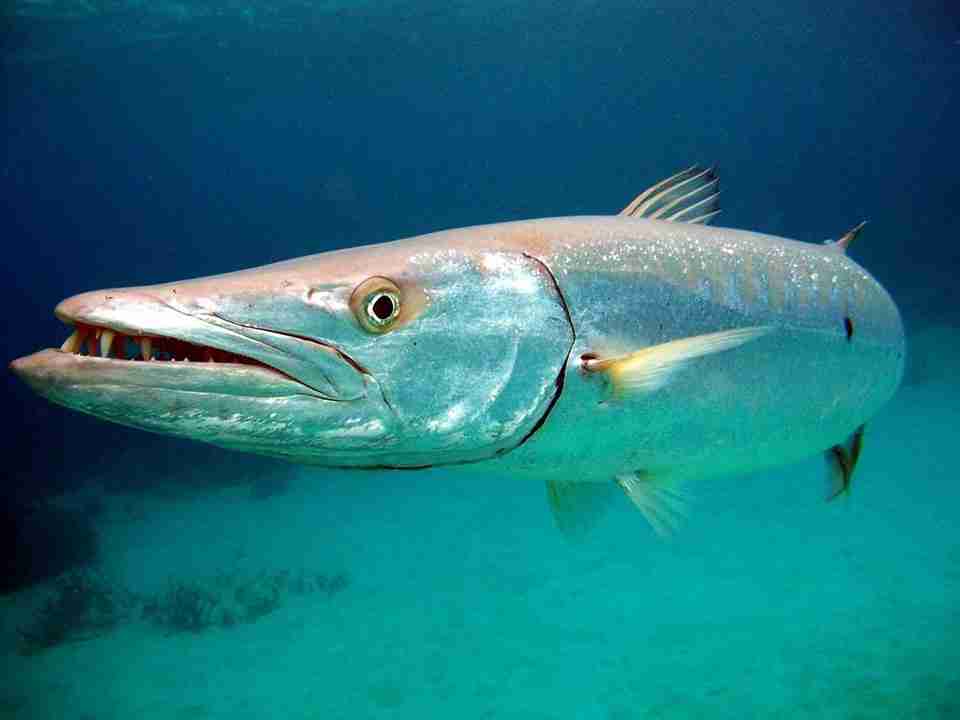
Meanwhile, lionfish, glassfish and some substantial groupers (Epinephelus sp.) live inside those crevices. Once past the tip of the wall, turn into the bay itself and cross a sandy slope studded with pinnacles, a genuine coral garden. Further, jackfish, barracuda and the occasional tuna hunt out in the blue.
Watch for
- Hold ten to fifteen metres if you want the chimneys, which are the highlight
- Then the current, which strengthens noticeably around the headland
- The northernmost chimney gives the most dramatic light of the three
Ras Burg
27°45.376′ N · 34°15.162′ E
Certainly, roughly five hundred metres south of Ras Za’atar sits a site few guides propose. Admittedly it is the less spectacular of the two, yet the wall is built on the same pattern and it carries two advantages: almost nobody dives it, and it is practically untouched.
Notably, a fossil coral pinnacle stands a couple of metres out of the water like a tower, which is how the site got its name, since Ras Burg is Arabic for Tower Cape. Next, descend the wall to about twenty metres with it on your right, past bluespine unicornfish (Naso unicornis) and schools of fusiliers (Caesio sp.). After a few dozen metres a wide chimney opens with its summit exposed, much like the one at Za’atar.
Specifically, inside there are yellow gorgonians of a startling brightness, red sponges (Cliona vastifica), siphon sponges, butterflyfish and anthias, and the upper section forms an arch whose roof climbs to 3.5 metres. Afterwards keep along the wall, past pinnacles of every shape, until a second and far plainer chimney marks the gradual ascent to the end. Overall, hawksbill turtles, jackfish and fusiliers are regular company throughout.
Watch for
- Above all, small groups only, since the first chimney is narrow
- Therefore no more than three or four divers inside it at once
- Also midday, when the sun sits overhead and the chimney lights up
- The site is generally sheltered from both wind and swell
Ras Mohammed diving along the eastern coast
Meanwhile, below the bay the cliff runs south towards the headland. Here the Ras Mohammed diving changes character: caves and light replace open wall, and one site trades spectacle altogether for a single, patient piece of natural history.
Jackfish Alley
27°46.000′ N · 34°15.400′ E
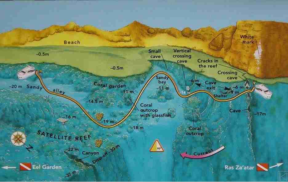
Naturally, the name comes from a wide sandy road between the coral ledge along the shore and a satellite reef running parallel to it, a corridor that jackfish and other predators patrol. Older charts call the site Fisherman’s Bank, and some crews still say Ras Kusba. Usually, a white mark on the cliff makes the drop-in easy to find.
First, descend to six metres and the entrance to the first cave is immediately in front of you. Notably, it runs about forty metres into the reef, and you leave it on your left at nine metres. Next, work southwest with the reef on your right until a large coral outcrop appears; just beyond it, at fourteen metres, a second cave climbs to a wide exit at six. Glassfish fill it completely.
A little further south a sandy bay has to be crossed on a southwest heading. At eleven metres another outcrop stands there, alive with a second glassfish colony. Finally, past a stretch thick with madrepores, the sandy alley itself opens at eighteen to twenty metres. Notably, whitetip reef sharks, manta rays, jackfish, blue triggerfish (Pseudobalistes fuscus) and bluespotted stingrays have all been seen working it.
Watch for
- First, do not drop below five or six metres at the start, or you will miss the first cave
- Caves are for small groups of experienced divers only
- Also carry a torch, and keep the time inside them short
Eel Garden
27°45.900′ N · 34°15.200′ E
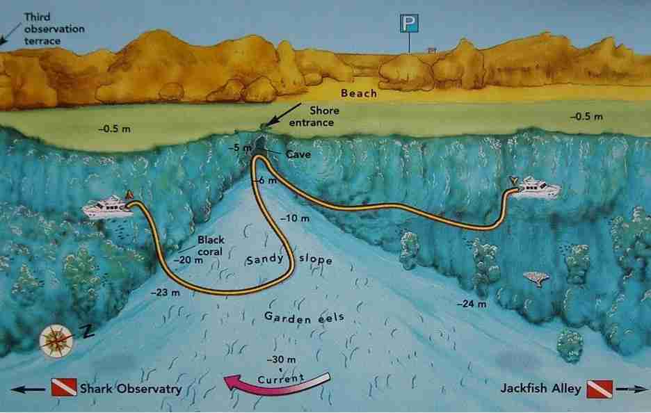
Similarly, facing a small beach between Jackfish Alley and Shark Observatory, this is one of the few places where the fossil cliff drops low enough to let you walk in. Currents barely reach it. Wind and swell do, however, so check the sea before committing, particularly from the shore.
Admittedly, very few divers bother with it, which is a shame, because biologically it is one of the more interesting stops in the park. Instead, the route crosses a sandy plateau tilted gently east in front of the beach. Notably, a small cave in the middle of the ledge appears to pour out a V-shaped river of sand.
Above all, beyond that lies the colony itself: garden eels (Gorgasia sillneri), a Congridae endemic to this sea, which can pass eighty centimetres. Indeed, two-thirds of each animal stands clear of the sand, swaying in the current after plankton. Besides, their lairs are cylindrical shafts held together by a secretion from a gland near the tail, and they never leave them. Approach carefully, because at the first hint of movement the whole colony vanishes.
Watch for
- First, never dive it in waves, especially if you are entering from the beach
- Then approach the eels from the north, and slowly
- Mornings give the best light for photographing them
- Also worth snorkelling, since everything sits shallow
Shark Observatory, the Ras Mohammed Wall
27°44.005′ N · 34°15.605′ E
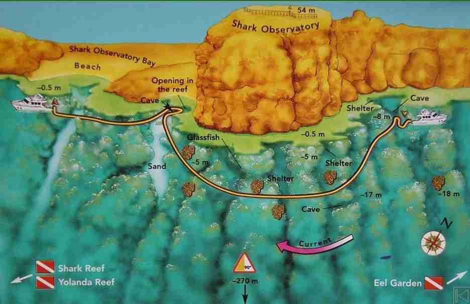
Firstly, the name belongs to the terrace on top of the promontory, sixty metres above the water, and also to the dive that runs beneath it. Divers usually call it the Ras Mohammed Wall, and it is the signature dive of the whole park. Looking out rather than down is the point here: large predators cross the blue constantly, hawksbill turtles come past, and a whale shark (Rhincodon typus) has been recorded.
Next, begin near the second observation terrace on the cliff. Descend to roughly fifteen metres and hold that, since the route is long and few divers have the gas to run it deeper. Then, work the wall on your left, which is dense with Alcyonarians and cut by gullies, shelters and caves, while keeping half an eye on the open water for jackfish, barracuda and sharks.
Soon, level with the southern corner of the promontory the wall swings sharply west and heads for the small beach below the observatory. Specifically, here large gorgonians (Subergorgia hicksoni) stand out, and higher up a majestic overhang cuts back into the rock. Finally, continue and the dive finishes in a genuinely beautiful cave, split at the top by a fissure that lets the light in, with an exit straight onto the reef.
Watch for
- Check the current first, because an ebbing tide gives the better dive
- Hold fifteen to twenty metres, then finish between eight and five
- Afternoon light is what makes the cave worth the swim
Shark and Yolanda Reefs, with Anemone City
27°43.300′ N · 34°15.000′ E · 10–30 m · no mooring
Ultimately, at the very southern end of the peninsula the classic route finishes with three names that need no introduction: Anemone City, Shark Reef and Yolanda Reef. Their full write-up sits on its own page, Shark and Yolanda Reef. Any list of Ras Mohammed diving ends here, where the current running around the tip is strongest, and where the pelagic traffic is heaviest as a result, particularly through the summer months.
Specifically, there is no shamandura anywhere on the site, so it has to be a drift, and it runs from Shark towards Yolanda. Boats drop divers at Anemone City or on Shark Reef itself. The plateau sits between ten and twenty-five metres, the Yolanda cargo field between ten and thirty, and below the drop-off the wall keeps falling to roughly nine hundred. Therefore plan the entry with the skipper, agree the pickup before anyone enters the water, and carry an SMB without exception.
Choosing between the Ras Mohammed diving sites
In short, the table below groups the sites by level rather than by geography, so you can match a reef to the day. The number in the first column matches the index above, which makes it easy to jump back to the full write-up.
| # | Site | Entry | Level | Why go |
|---|---|---|---|---|
| 5 | Eel Garden | Shore or boat | Beginner | The finest garden eel colony in the park |
| 1 | Ras Ghozlani | Drift | All levels | Untouched table corals, a coral forest |
| 6 | Shark Observatory | Drift | Intermediate | The great wall, pelagics and a light cave |
| 2 | Ras Za’atar | Drift | Intermediate | Chimneys full of sunlight at 10–15 m |
| 7 | Shark & Yolanda | Drift | Intermediate | The classic finish at the southern tip |
| 3 | Ras Burg | Drift | Intermediate | A quiet wall with one spectacular chimney |
| 4 | Jackfish Alley | Drift | Advanced | Two caves and a predator corridor |
Marine life on the Ras Mohammed diving sites
Pelagics
Barracuda, jackfish and tuna work the current line, especially between June and August when the plankton peaks.
Sharks
Also, whitetip reef sharks along Jackfish Alley, larger species out in the blue off the wall, and rarely a whale shark.
Garden eels
Gorgasia sillneri, endemic and up to eighty centimetres, holds a whole plateau at Eel Garden.
Glassfish
Parapriacanthus ransonneti fills the caves at Jackfish Alley and the chimneys at Za’atar and Burg.
Corals
218 species between them, from Acropora tables to black coral (Antipathes dichotoma) on the deeper walls.
Birds
220 species pass through, and white storks stop here each autumn on the way from Europe to southern Africa.
Planning a day of Ras Mohammed diving
Practical notes
- First, expect a park fee and a briefing before anyone gets in the water
- Then remember that only one sheltered mooring exists, at The Quay
- Also, almost every site here is a drift rather than a there-and-back
- Consequently an SMB is not optional on any of these dives
- Agree the pickup point at the briefing, never in the water
- Meanwhile watch the sea state if you plan to enter from the shore
- Finally, nothing is collected and nothing is touched inside the park
Depth discipline matters most on the wall. Shark Observatory runs long, so fifteen metres is the working depth rather than a suggestion. Similarly, the chimneys at Za’atar and Burg are shallow features, and diving deep simply means missing them.
Useful links
- Shark and Yolanda Reef — a one-way drift over the cargo field and the wall.
- The local reefs around Naama Bay — eighteen sites, twenty minutes from the marina.
- The Strait of Tiran — Jackson, Woodhouse, Thomas and Gordon.
- Safety standards and emergency care — briefings, oxygen and chamber contacts.
- Red Sea conditions and planning guide — currents, visibility and weighting.
- Red Sea Liveaboard — safari routes and boats across the Egyptian Red Sea.
- Divers Alert Network (DAN) — insurance and emergency guidance.
Frequently asked questions
Which site suits a first visit?
Eel Garden, because it is shallow, sheltered from current and reachable from the beach. Equally, Ras Ghozlani works well too, provided the drift is briefed properly.
When is the best time of year?
Ras Mohammed diving peaks from June to August, when the plankton arrives and the barracuda, jackfish, tuna and sharks follow it. Visibility is generally good year-round.
Can these sites be dived from the shore?
Eel Garden can, since the cliff drops low enough there to let you walk in. Otherwise, everything else is a boat drift, and the park has only one sheltered mooring.
How difficult are the caves at Jackfish Alley?
They are short but genuinely enclosed, so they suit small groups of experienced divers carrying torches. Nobody should linger inside them.
Is there a park fee?
Yes. Ras Mohammed has been a national park since 1983, only a tenth of it is open to visitors, and access is charged and controlled.
Where are the garden eels?
On the middle of the sandy plateau at Eel Garden. Certainly, approach from the north and move slowly, otherwise the whole colony drops back into the sand.
What are you waiting for?
Book your adventure
Tell us which experience you want to enjoy and leave the rest to us. If you have questions, or you are still choosing between routes, our team will talk it through with you before you commit to anything.
Inquiry