
Local reefs · Sharm el-Sheikh diving
Sharm el-Sheikh Diving Eighteen reefs north and south of Naama Bay
Sharm el-Sheikh diving happens along one short stretch of coast, between the green beacon at Ras Ghamila and the lighthouse at Ras Umm Sid, where the shore folds into a run of bays, walls, canyons and coral gardens. Moreover, most of them sit twenty minutes from the marina, and most can be done as a gentle drift. Indeed, several are good enough that visiting divers come back for them alone.
How the Sharm el-Sheikh diving coast is laid out
Almost every reef on the Sharm el-Sheikh diving coast follows the same three-part shape: first a shallow platform against the shore, then a sandy slope or plateau, and finally a drop-off into the blue. However, what changes from site to site is how wide that plateau is, how deep the drop-off starts, and what sits on top of it.
North of Naama Bay the plateaus are broad and forgiving, so the Gardens and the bays around Ras Nasrani suit newer divers and snorkellers. By contrast, south of the bay the shelf narrows, the walls steepen, and sites like Tower and Pinky Wall fall away almost vertically for more than a hundred metres.
Current on the Sharm el-Sheikh diving sites is tidal and generally mild, although it accelerates around every headland. The rule of thumb is simple: check which way the water is running before you drop in, and plan the drift with it rather than against it.
Reading the tide
- Flood tide pushes north, so drifts run towards Ras Ghamila
- Ebb tide pushes south, which is when Paradise and Middle Garden work best
- Also the current speeds up at Ras Nasrani, Ras Umm Sid and Ras Katy
- Besides, wind builds from the north through the morning, easing after lunch
- Then the southern bays stay sheltered when the north is unworkable
- Finally, low tide makes shore entries risky for the reef, so wait for water
Fixed moorings matter here. Where a shamandura exists, the dive can be a relaxed there-and-back. By contrast, where there is none it becomes a drift, which means agreeing the pickup with the boat before anyone gets in.
Jump to a reef
Sharm el-Sheikh diving north of Naama Bay
Altogether, nine reefs run from the beacon at Ras Ghamila down to the last of the Gardens. Consequently, this is the sheltered half of the Sharm el-Sheikh diving coast, and it is where most check dives and first days in the water happen.
Ras Ghamila
27°58.342′ N · 34°25.684′ E
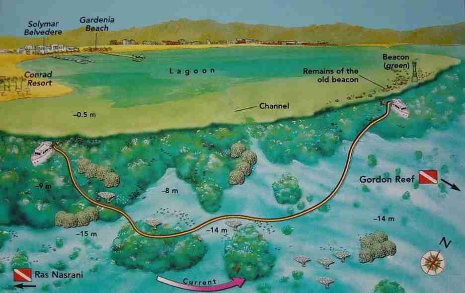
The name means delightful cape, and although it appears on no official chart, every skipper knows it. In fact, it marks the tongue of reef that carries the green beacon at the western end of the Strait of Tiran: every ship leaving Aqaba or Eilat has to pass between this light and the red and white one on Gordon.
Usually, the classic route starts just past the Conrad Resort and glides north at about fifteen metres, parallel to the edge, over a broad sandy plateau. Table corals stand across the sand with schools of pelagics turning around them, while the gentler slope inshore, around eight metres, carries big colonies of Porites. Giant triggerfish pass through often.
Watch for
- Head straight out to sea once you reach the beacon, so the boat can collect you
- Also the current, which can pick up sharply at the point itself
- Moreover, follow this route whenever the tide is flooding
Ras Nasrani
27°57.809′ N · 34°24.938′ E
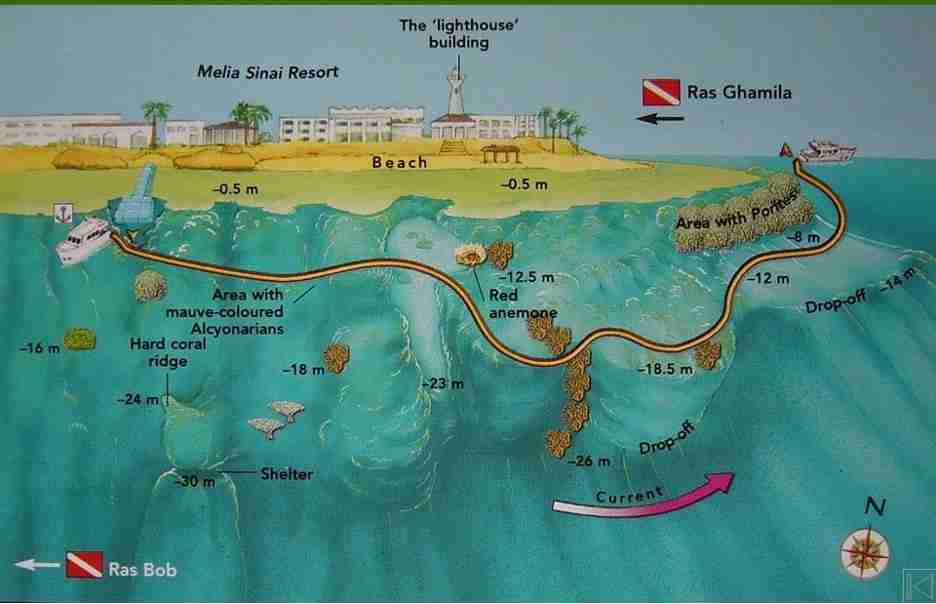
Christian cape in Arabic, eleven kilometres north of Naama Bay and just south of Ras Ghamila. It can be reached by road via the Baron and Conrad resorts, but the usual approach is by boat. Drop from the pontoon by the hard coral ridge, look into the shelter that opens at thirty metres, then rise slowly to a submerged sandy bay with a striking red anemone on its northern side at 12.5 metres.
From there the sand gives way to coral and you work north with the reef on your left, letting a weak to moderate current carry you. Then, past the gorgonians at around twenty metres, banks of massive Porites take over and grow denser beyond the headland. Notably, this stretch holds the highest density of giant clams (Tridacna sp.) anywhere in the Red Sea, their mantles blue or green from the algae inside them.
Watch for
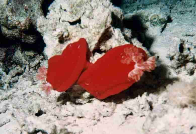
- In addition, Spanish dancers (Hexabranchus sanguineus) on night dives
- Also crustaceans tucked between the hard corals, if you look slowly
- Then the current, which quickens as you approach the cape
Ras Bob
27°57.791′ N · 34°24.665′ E
You will not find this on a chart, and the locals do not use it either. Sharm instructors coined it years ago for the southernmost part of Ras Nasrani, in tribute to the underwater cameraman Bob Johnson, who filmed here for years. It sits sheltered from wind and swell, and the current is usually weak.
Boats tie to the shamandura at twenty metres. The route runs northeast between fifteen and twenty metres to an agreed turn point, then back along the small ledge. Still, the real interest is shallow: a run of small sandy bays between three and six metres, riddled with little caves and gullies, where crocodilefish (Papilloculiceps longiceps) and bluespotted stingrays (Taeniura lymma) lie on the sand.
Watch for
- The best of it sits between four and twelve metres, so do not rush deep
- Also, in good conditions, a drift through to the Ras Nasrani mooring
- Snorkellers can work either side of the mooring with no trouble
White Knight
27°57.627′ N · longitude to be confirmed
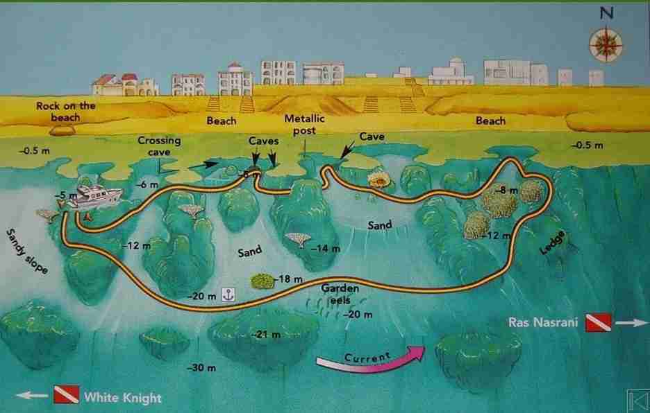
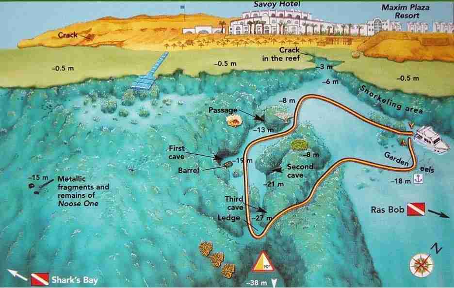
A small bay backed by a well-developed reef, with a large crevice opening onto a sandy plateau between six and eighteen metres. Meanwhile, the mooring sits beside a colony of garden eels (Gorgasia sillneri). On the southwestern side, at eight metres, a beautiful canyon runs down to thirty-eight metres, its eastern flank built from two coral buttresses carrying a large Acropora formation and a salad coral (Turbinaria mesenterina).
A tunnel starts at ten metres beside the canyon entrance and breaks through at thirteen. A metal drum at nineteen metres marks a cave mouth, with a second cave opposite at twenty-one. Then, at twenty-seven metres, a small ledge overhangs a genuine sand fall, which is where the name Wichita Falls came from. A third cave opens on the left of that ledge and runs steeply upwards.
Watch for
- Depth discipline: the canyon floor is well past recreational comfort
- Also the remains of the Noose One, a boat lost to fire in 1994
- Notably, little is left of her now beyond cylinders and engine parts
Sharks Bay
27°57.074′ N · 34°23.097′ E
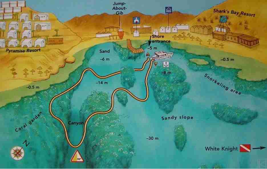
No sharks, despite the name, which most likely comes from the fishermen who once landed their catch here. What there is instead is a long sandy beach, a resort with its own centre at the northern end, and a steady flow of visitors. Furthermore, shore entry is possible for a fee; boats use the fixed moorings in the bay.
The route passes large coral heads rising off the sand, then turns into the deep sandy canyon on the southwestern side. Follow it to thirty metres, then climb gently to eighteen to work the plateau and the ledge, which carries a genuinely good range of hard corals and Alcyonarians.
Watch for
- Manta rays, most often in summer
- Then the plankton, which can cut visibility badly in the warmer months
- Also litter on parts of the sandy floor, which is a real problem here
- On night dives, the rare cone shell Conus textile — look, do not touch
Far Garden, a highlight of Sharm el-Sheikh diving
27°54.924′ N · 34°21.531′ E
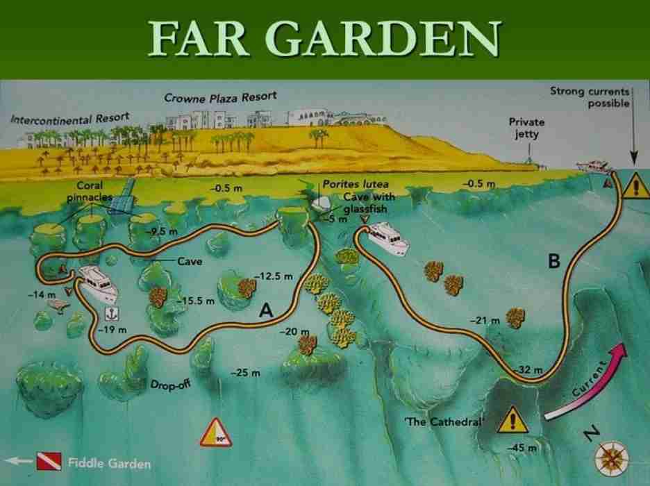
The northernmost of the Gardens, and the one that earns the name. Above all, what sets it apart is a line of large coral pinnacles standing between the ledge and the drop-off, spaced about thirty metres apart, each carrying an extraordinary mix of hard and soft coral. Anthias, lionfish, fusiliers and sergeant majors work between them constantly.
Route A tours the pinnacles and finishes at a cave at five metres, crowned by Porites lutea and packed with glassfish. Route B leaves that cave on a diagonal descent to thirty metres, where the top of a vast overhang comes into view: the Cathedral, opening at about thirty-two metres and cutting a dozen metres into the reef. Finally, from there you ascend with the reef on your left to a large private jetty that marks the end.
Watch for
- Scorpionfish (Scorpaenopsis sp.) and nudibranchs, mostly after dark
- Also shelter from wind and swell, which makes this a reliable fallback
- Route B needs settled weather, so do not force it
Fiddle Garden
Between Far Garden and Middle Garden
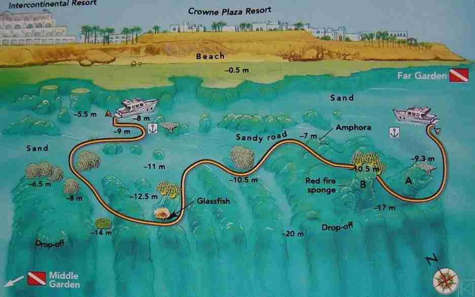
Named by local instructors for sitting almost exactly halfway between its two neighbours. Two fixed moorings about two hundred metres apart and a well-sheltered position keep it busy. Moreover, the seabed is flat, sandy and shallow, averaging around ten metres, with coral structures framing sandy lanes and massive Porites pushing up through them.
Two pinnacles define the site, rising from seventeen metres to 9.3. The second is dominated by fire coral and carries a big scarlet fire sponge (Latrunculia sp.), toxic to fish, grazed only by a few nudibranchs. Nearby, at 6.5 to 7 metres, lies a well-preserved amphora, probably Roman, with other fragments between the ledge and the mooring.
Watch for
- No meaningful current, which makes this a good check dive
- Also a sound alternative when Far Garden is packed
- However, the drop-off between fourteen and twenty metres is not worth the swim

Middle Garden
27°54.878′ N · 34°21.143′ E
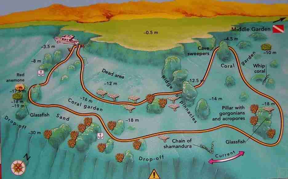
The central Garden, roughly in line with the Hyatt Regency, completely sheltered from wind, swell and current. Therefore, start level with the middle of the hotel where the floating pontoon sits. A wide sandy plateau runs onto a ledge ending at five or six metres, with the drop-off between twelve and fourteen.
After a few dozen metres the plateau narrows into a road of white sand bordered by Acropora, with massive Porites standing out of it like small islands. Notably, table corals scattered around create the little sandy avenues that gave the Gardens their name. Fusiliers, pufferfish, triggerfish, dominos, chromis and bluespotted stingrays are constant, and spotted eagle rays (Aetobatus narinari) cross through.
Watch for
- Divers with good air can push on to the Fiddle Garden pinnacles
- Also a southwest drift to Near Garden on an ebbing tide
- Then the crowds: this is everyone’s lunch mooring in late morning
- Manta rays (Manta birostris) turn up in summer
Near Garden
27°54.401′ N · 34°20.833′ E
Closest to Naama Bay and the most southerly of the Gardens. However, it has taken damage over the years, from sheer diver numbers and from construction debris dumped on the coral, and the pale stretch in the southwest sector is now openly called the dead area. Still, it remains worth diving, and its location makes it a dependable afternoon or night option.
Descend to the sandy plateau at fifteen to twenty metres, edged along the drop-off by hard coral heads. Then, work past the gorgonians to a ridge of four pinnacles running northwest to southeast, each deeper than the last. Finally, beyond the ridge, turn north into the gullies and squeeze the narrow passage between two coral formations where cave sweepers (Pempheris vanicolensis) shelter.
Watch for
- Napoleon wrasse (Cheilinus undulatus) and triggerfish throughout
- Also a resident whitetip reef shark (Triaenodon obesus)
- Then the option, in the right conditions, of continuing to Middle Garden

Sharm el-Sheikh diving south of Naama Bay: Sodfa to Ras Katy
South of the bay the shelf narrows and the walls stand up. Therefore this is where the serious Sharm el-Sheikh diving is: the canyons, the gorgonian forests and the amphora fragments, and a few sites that genuinely need a careful briefing rather than a casual one.
Sodfa
27°53.015′ N · 34°19.724′ E
Sodfa sits just along from its better-known neighbour Tower, off a small promontory carrying four resorts. The jetty belongs to hotel guests, so almost everyone arrives by boat and dives it as a drift. Generally, two routes are possible: west towards Tower, or east towards Ras Umm Sid.
Both run along a sandy slope averaging twelve metres, between the ledge and a drop-off at eighteen to twenty-two, with pinnacles on the slope and large gorgonians near the edge at twenty to twenty-two metres. Overall, the eastern route gives the fuller picture: more coral, more fish, and a steadier procession of fusiliers, surgeonfish, triggerfish, parrotfish, glassfish, bannerfish and lionfish.
Watch for
- Check the current first: if it runs north on a flood, reverse the route
- Also the quiet, since this site takes the overflow from Tower rather than the crowd

Tower, the deepest canyon in Sharm el-Sheikh diving
27°52.948′ N · 34°19.539′ E
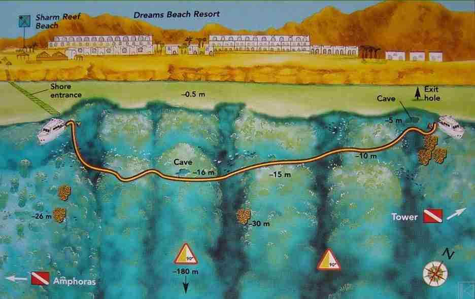
A canyon whose walls fall vertically for more than a hundred and twenty metres, named after the fossil coral tower on the little beach. Shore access is possible for a fee through the Tower resorts, and entering there is the more dramatic way in: swim past the ledge and the floor simply disappears beneath you.
Next, keep the reef on your left and drop to fifteen metres to reach the edge of a gently inclined sandy plateau running from twelve to twenty-five metres with a few pinnacles on it. Come back along the same line but shallower, at five to twelve metres, working the crevices and caves. Two large caves near the beach at about five metres hold glassfish, lionfish, sabre squirrelfish and bigeyes.
Watch for
- Depth creep in the canyon, which is very easy here
- Also the tide if you enter from shore, since low water means reef damage
- Then the five to twenty metre band, which holds most of the life
- Finally, a drift through to Sodfa if you came by boat

Pinky Wall
27°52.242′ N · 34°19.389′ E
Named for the mass of pink Alcyonarians on it, and strangely overlooked: few guides propose it despite the quality of the wall. Indeed, the shape is unlike anything else on this coast. The coral platform is very narrow, and the wall drops almost sheer for more than a hundred and eighty metres, studded with Dendronephthya the whole way.
There is no mooring, so it is a drift. Keep the reef on your left at around fifteen metres, which is where the soft coral is thickest. Moving northeast, a sequence of gullies cuts the vertical face like organ pipes. Parrotfish, wrasse and groupers including the moon grouper (Variola louti) work along it, and in the right current you can reverse and run through to Amphoras.
Watch for
- Calm seas only — there is nowhere to hide on a wall like this
- Also depth, because there is no bottom to stop you
Amphoras
27°51.965′ N · 34°19.412′ E
The name comes from a seventeenth-century Turkish ship that went down here carrying amphoras of mercury. The topography is straightforward: a sandy slope starting around a dozen metres, with pinnacles crusted in multicoloured Dendronephthya that turn the whole slope into a garden.
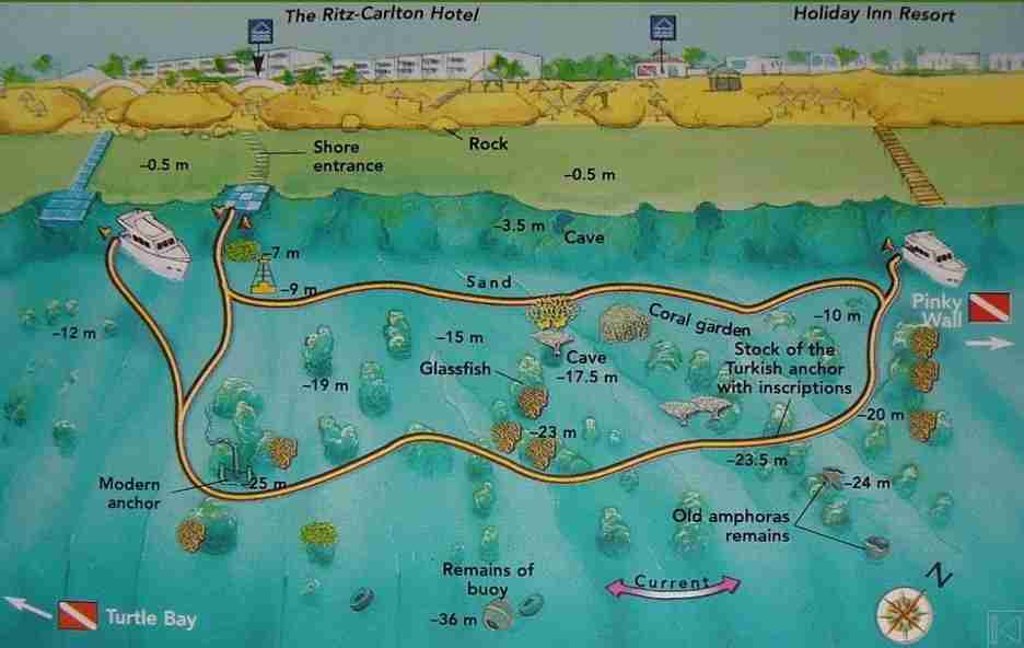
Enter by the half-submerged concrete jetty a dozen metres north of the floating pontoon. Next, at twenty-two metres a long chain leads to a large modern anchor behind a pinnacle at twenty-five. Work north with the reef on your left past coral towers, one ringed with anthias and holding glassfish in its splits, then a huge table coral. Behind the pinnacles beyond it, at 23.5 metres and fixed into the reef, the ship’s original anchor stock still carries its inscriptions, with amphora fragments scattered around it.
Watch for
- The best of the site sits between eighteen and twenty-five metres
- Also local current, which can be strong, and visibility, which can drop
- Then the fragments themselves, which take patience to find
Turtle Bay
27°51.746′ N · 34°19.221′ E
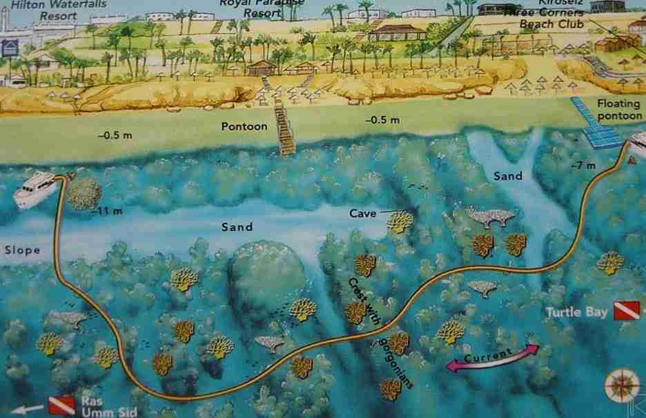
Immediately south of Amphoras and shaped much the same: a slope of roughly thirty degrees running from ten to twenty-six metres with pinnacles standing on it. The drift usually runs south, and the drop-off at the bottom of the slope marks the top of a wall falling about a hundred and ten metres.
Then, circle the coral towers, taking in the gorgonians between fifteen and twenty-three metres. The northern end crosses an area thick with madrepores and Alcyonarians, bordered by large salad coral (Turbinaria mesenterina) and mushroom-shaped heads of Porites. Above all, snorkellers get a good deal here: the ledge down to about ten metres carries butterflyfish, anthias, sergeant majors, royal angelfish, lizardfish and hawkfish.
Watch for
- A local current that can appear without much warning
- Also the option of continuing to Amphoras when conditions allow
- Meanwhile, the site stays quiet even in high season
Paradise
27°51.349′ N · 34°19.158′ E
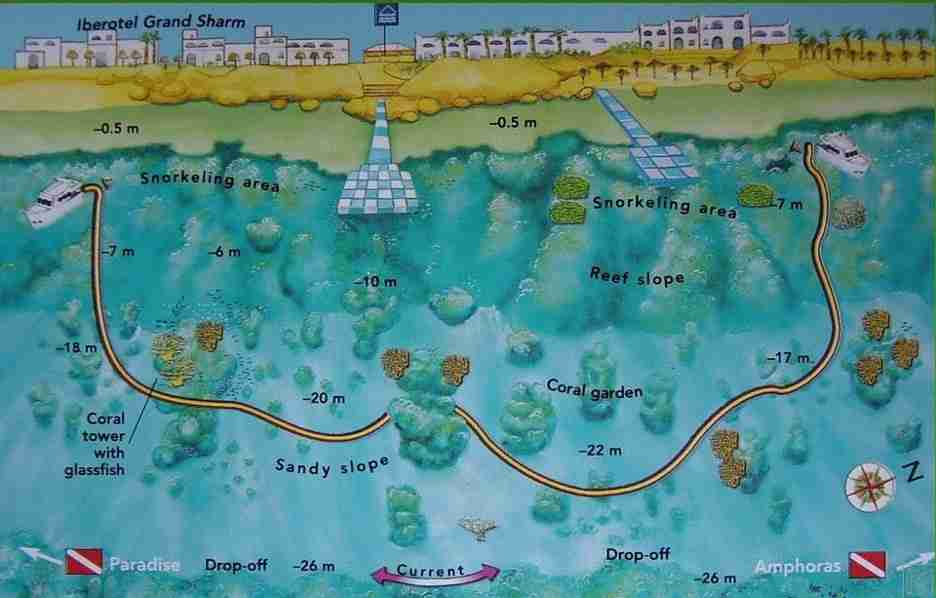
Same basic shape as its neighbours, but the pinnacles here are taller, and they look less like coral heads than like sculpture: red, pink and yellow Dendronephthya covering them from base to crown. The site runs between the two small beaches in line with the Royal Paradise Resort.
Shore access is possible with permission from the centre there, but the standard dive is a southward drift on an ebbing tide. Descend to twenty-four or twenty-eight metres near the drop-off and glide through the pink towers, some capped with Acropora, with larger table corals and gorgonians below. Parrotfish, Napoleon wrasse, clouds of butterflyfish and permanent anthias fill the water, and giant morays (Gymnothorax javanicus) hold the crevices at the southern end.
Watch for
- Ebb tide, when the southbound current runs fastest and the dive works best
- Also the soft coral colour, which is at its most intense here
Ras Umm Sid, the classic Sharm el-Sheikh diving site
27°50.832′ N · 34°18.833′ E
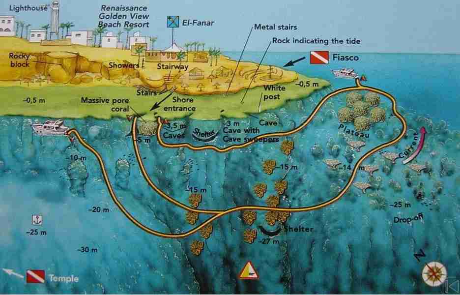
The headland with the tall lighthouse that marks the western start of the Strait of Tiran. The site lies just east of it, and it is famous for one thing: a forest of Subergorgia hicksoni gorgonians, the finest in the northern Red Sea. Shore access is by stairway, but only when the tide is high enough to clear the platform.
From the huge Porites head crowned with anthias, drop to twenty-five metres and pass through the forest, then climb to the plateau at fourteen. Among the pinnacles there, hundreds of reef fish, lionfish, parrotfish and big Napoleon wrasse circulate. From shore, return shallow at five or six metres with the reef on your right to work the gorges and the small caves full of glassfish and cave sweepers. By boat, carry on towards Paradise across the wide Fiasco Plateau.
Watch for
- Strong current near the cape, which is the norm rather than the exception
- Also the tide: high water is when the rocky bluff on the reef is nearly covered
- Then jackfish, barracuda and tuna out in the blue
- Night dives, when the parrotfish sleep in their mucus cocoons
Temple
27°51.000′ N · 34°18.600′ E
Three coral pillars stand on a sandy plateau between six and thirty metres, and they looked enough like the columns of a temple to the first divers here in the early 1970s that the name stuck. The largest reaches the surface and carries a black post; moorings sit around it, and the bay takes no wind or swell at all.
That combination makes Temple one of the busiest sites in Sharm el-Sheikh diving, and it has paid for the attention. It is still a good dive, and an excellent night one. Butterflyfish, parrotfish, lionfish, batfish and Napoleon wrasse are close to guaranteed. The site is small enough to plan your own route, but include the gorgonian with glassfish at about thirty metres on the edge of the drop-off.
Watch for
- Carry a compass at night, since the return to the boat is easy to lose
- Also triggerfish during nesting season, which will come at you

Ras Katy
27°50.838′ N · 34°18.107′ E
A few hundred metres west of Temple and built along similar lines. Boats moor bow-to at the shamandura beside a large coral pillar that rises almost to the surface, colonised by small table corals and raspberry coral (Pocillopora verrucosa). Shelter from the prevailing wind is good here.
Meanwhile, a sandy floor tilts gently from about five metres down to eighteen or twenty at the drop-off, where gorgonians grow. Two more pinnacles stand out on the plateau a few dozen metres apart, covered in Alcyonarians and broccoli soft coral (Lithophyton arboreum), worked over by anthias, butterflyfish, dominos and fusiliers. Glassfish, lionfish and bigeyes hold the crevices; crocodilefish, bluespotted stingrays and scorpionfish sit on the sand.
Watch for
- A rising tide, which can push a drift the four hundred metres through to Temple
- Also afternoons, which are the better half of the day here
- Then triggerfish in nesting season, same as at Temple

Choosing between the Sharm el-Sheikh diving sites
In short, the table below groups every reef by level, so you can match a site to the day rather than to a reputation. The number in the first column matches the index above, so you can jump straight back to the full write-up.
| # | Site | Entry | Level | Why go |
|---|---|---|---|---|
| 3 | Ras Bob | Mooring | Beginner | Shallow caves and gullies, sheltered |
| 5 | Sharks Bay | Shore or boat | Beginner | Check dives, mantas in summer |
| 7 | Fiddle Garden | Mooring | Beginner | Roman amphora, no current |
| 8 | Middle Garden | Mooring or drift | Beginner | White sand avenues, eagle rays |
| 17 | Temple | Mooring | Beginner | Three pillars, superb night dive |
| 18 | Ras Katy | Mooring | Beginner | Easy plateau, good afternoon option |
| 6 | Far Garden | Mooring or drift | All | Pinnacles and the Cathedral overhang |
| 1 | Ras Ghamila | Drift | All | Wide plateau, table corals, rarely busy |
| 10 | Sodfa | Drift | All | Quiet alternative to Tower |
| 2 | Ras Nasrani | Drift or mooring | All | Highest giant clam density in the Red Sea |
| 13 | Amphoras | Shore or boat | All | Anchor stock and amphora fragments |
| 14 | Turtle Bay | Drift | All | Coral garden, uncrowded in season |
| 15 | Paradise | Drift | All | Tallest, most colourful pinnacles |
| 11 | Tower | Shore or boat | Intermediate | 120 m canyon, shallow caves |
| 16 | Ras Umm Sid | Shore or boat | Intermediate | The gorgonian forest |
| 9 | Near Garden | Drift | Intermediate | Pinnacle ridge, resident whitetip |
| 4 | White Knight | Mooring | Advanced | Canyon, three caves, the sand fall |
| 12 | Pinky Wall | Drift | Advanced | Sheer 180 m wall of soft coral |
Marine life on the Sharm el-Sheikh diving sites
Because the reefs share one current system, the same cast turns up across the whole coast. Nevertheless, a few species are reliably tied to particular sites.
Soft corals
Dendronephthya in red, pink and yellow covers the pinnacles at Paradise and the whole face of Pinky Wall.
Gorgonians
Subergorgia hicksoni forms a forest at Ras Umm Sid, with smaller stands at Sodfa, Turtle Bay and Ras Katy.
Giant clams
Tridacna sp. reaches its highest Red Sea density at Ras Nasrani, mantles blue or green from their algae.
Rays
Bluespotted stingrays on almost every sandy floor, spotted eagle rays through the Gardens, mantas in summer.
Glassfish
Parapriacanthus ransonneti fills the caves at Far Garden, Tower, Temple and Ras Umm Sid.
Night species
Spanish dancers at Ras Nasrani, scorpionfish and nudibranchs at Far Garden, sleeping parrotfish at Ras Umm Sid.
Planning a day of Sharm el-Sheikh diving
Practical notes
- First, dive the north early, before the wind builds through the morning
- Also keep the southern bays in reserve for when the north gets choppy
- Similarly, check the tide direction before every drift, without exception
- Then carry an SMB, since most of these dives end away from the boat
- Above all, agree the pickup point at the briefing, not in the water
- Wait for enough water before any shore entry, to spare the reef
- Finally, give nesting triggerfish room at Temple and Ras Katy
Depth discipline matters most at three Sharm el-Sheikh diving sites: Tower, White Knight and Pinky Wall. All three have a floor far below recreational limits, and all three make it easy not to notice.
Useful links
- The Strait of Tiran — Jackson, Woodhouse, Thomas and Gordon, an hour north.
- Dahab dive sites — the Blue Hole, the Canyon and the reefs around the bay.
- Safety standards and emergency care — briefings, oxygen and chamber contacts.
- Red Sea conditions and planning guide — currents, visibility and weighting.
- Red Sea Liveaboard — safari routes and boats across the Egyptian Red Sea.
- Divers Alert Network (DAN) — insurance and emergency guidance.
Frequently asked questions
Which site is best for a first dive?
Temple or Ras Katy. Both have fixed moorings, no meaningful current and a shallow plateau, which is everything a first day of Sharm el-Sheikh diving needs.
Which sites can be dived from the shore?
Tower, Amphoras, Ras Umm Sid, Sharks Bay and Paradise, though several charge an entry fee through the resort and all of them need enough tide to clear the reef platform safely.
Where is the best chance of seeing a shark?
Near Garden has a resident whitetip reef shark. For anything larger you want the Strait of Tiran rather than the local reefs.
When do the mantas come?
Summer, most often at Sharks Bay and Middle Garden. They are not guaranteed and no honest guide will promise them.
Which sites are good for snorkelling?
Ras Bob, Far Garden, Turtle Bay, Temple and Ras Katy all have shallow ground worth the time, with the reef life close to the surface.
Are these sites busy?
Temple, Middle Garden and Sharks Bay fill up, especially around midday. Sodfa, Turtle Bay and Pinky Wall stay quiet even in high season.
What are you waiting for?
Book your adventure
Tell us which experience you want to enjoy and leave the rest to us. If you have questions, or you are still choosing between routes, our team will talk it through with you before you commit to anything.
Inquiry