
Sinai, Egypt · Dahab Local Dive Sites
Dahab Local Dive Sites Six shore and boat entries between Ras Abu Galum and the Caves
28°36.714′ N to 28°25.000′ N · 3–22 m · Six sites along one coast
These six Dahab local dive sites cover the whole coast, from a protected wilderness in the far north to a pair of shallow caves in the deep south. Most are entered from the beach, and several can be dived twice without repeating anything. Below you will find coordinates, depths and the route for each.
The six Dahab local dive sites at a glance
Firstly the shape of the coast: the sites run north to south over roughly twenty kilometres, and only one of them needs a boat. Consequently a week in Dahab can cover all six without repeating a single entry.
| Site | Coordinates | Depth | Entry |
|---|---|---|---|
| Ras Abu Galum | 28°36.714′ N, 34°33.204′ E | 4–15 m | Camel, 4×4 or boat |
| Ras Abu Helal | 28°32.533′ N, 34°30.967′ E | 7–12 m | Shore, by the old sign |
| Islands | 28°28.668′ N, 34°30.706′ E | Shallow labyrinth | Shore, at a cleft in the reef |
| Napoleon Reef | 28°28.250′ N, 34°30.456′ E | To 20 m | Boat or zodiac, 450 m out |
| Three Pools | 28°26.267′ N, 34°27.450′ E | 3–20 m | Shore, big signboard |
| Caves | 28°25.000′ N, 34°27.364′ E | 3–22 m | Shore, unmarked crack |
Tide rules everything. Wherever a reef platform has to be crossed, high water protects both the coral and your ankles. That applies to Islands, Three Pools and the Caves in particular.
Booties, not just fins. Namely these entries cross rock, gravel and reef plate rather than sand. Consequently the walk in does more damage to bare feet than anything underwater will.

The six Dahab local dive sites, north to south
Each card below carries the coordinates, the depth range and the route as it is actually dived. Above all, book a guide for a first visit: several of these entries are unmarked, and one of them is a crack in the reef plate with nothing beside it.
Ras Abu Galum
28°36.714′ N · 34°33.204′ E
Firstly the wildest of the Dahab local dive sites, eight kilometres north of the Blue Hole. A coastal path links the two, so most divers arrive on foot or by camel in about ninety minutes. Alternatively a four-wheel drive takes the track leaving the asphalt twenty kilometres before Nuweiba, running down Wadi Rasasa to the Bedouin village of El-Omeyid.
South Ras Abu Galum
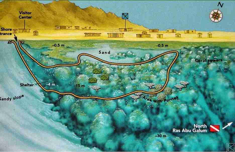
Enter beside the small visitor centre. After skirting a cave at four metres, drop to ten or twelve, pass the spur marking the reef boundary and keep the coral on your left. Further east come salad corals (Turbinaria) and massive porites, then madrepore towers. Turn back west at four to six metres across a plateau carrying huge banks of Lobophyllia hemprichii.
North Ras Abu Galum
Meanwhile this is the better dive, at 28°36.909′ N and 34°33.577′ E. Entry is through a split in the reef. Beyond a large porites and flat fire coral (Millepora platyphylla), a sandy bottom leads to a madrepore tower whose top nearly breaks the surface, ringed by scalefin anthias. Explore south first with the reef on your right, loop anticlockwise north to a group of towers, and exit through the same split.
Watch for
- Firstly pygmy and cave sweepers in the crevices of the tower
- Then masked butterflyfish, snappers and doublebar breams on the slope
- Also circular batfish, which hang off the deeper end of the route
- Finally the litter on the first stretch of the southern dive
A protected area since 1992. Namely five hundred square kilometres of reef, coast and mountain, holding over 165 plant species of which 44 grow nowhere else, plus Nubian ibex, red fox, hyrax and the horned viper in the wadis behind the coast. Park fees apply and rubbish leaves with you.
Ras Abu Helal
28°32.533′ N · 34°30.967′ E · 7 km north of Dahab
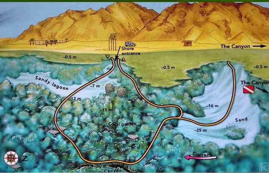
Then the quietest of the Dahab local dive sites. Its name means Cape of the Growing Moon, and it lies seven kilometres north of Dahab, which puts it three kilometres south of the Canyon. Although the coastline only dips slightly here, the reef builds an underwater buttress, and the whole dive circles it.
Enter from shore by the old sign just south of the buttress. You drop into a semicircular sandy lagoon between seven and twelve metres, then follow the reef with it on your left.
Watch for
- Firstly lionfish, morays and groupers working the face of the buttress
- Then anthias, triggerfish and unicornfish in numbers
- Also butterflyfish over the coral heads
- Finally turtles, drawn in by broccoli corals (Lithophyton arboreum)
Current warning. A strong flow can run from the north at the tip of the promontory. Consequently the route is often dived in reverse when conditions demand it, and that call belongs to the guide.
Islands
28°28.668′ N · 34°30.706′ E
Meanwhile few Dahab local dive sites match this one for sheer coral development. It sits south of Assalah where the sand spit begins its hook, with El-Qura bay closing it off to the north. A signboard on the beach shows the topography, and the dive starts at a small cleft in the reef.
Since the platform is wide, enter at high tide. Three hard-coral pools with sandy bottoms follow immediately. Afterwards leave the reef edge on your left and drop into a genuine labyrinth of massive porites. Getting lost in there is part of the fun.
Watch for
- Firstly the three coral pools right after the entry
- Then the porites labyrinth, which is the heart of the dive
- Also the submerged coral island east of the sandy road, which names the site
- Finally a resident school of juvenile yellowtail barracuda
Napoleon Reef
28°28.250′ N · 34°30.456′ E
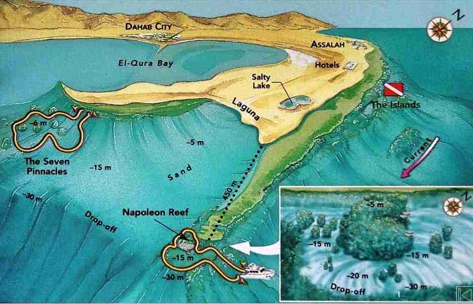
Then the only boat dive among the Dahab local dive sites. Napoleon Reef lies a few hundred metres from Islands, beside the sandy tongue bordering El-Qura bay and facing the big hotels across the water. Locals call the area Laguna, and it also contains a second site, the Seven Pinnacles.
Because the reef sits roughly four hundred and fifty metres offshore, a boat or zodiac is the sensible way in. The structure itself is one huge madrepore tower, cut off from the half-submerged reef by a channel and rising from sand at around twenty metres.
Watch for
- Firstly the Napoleonfish (Cheilinus undulatus) that names the site
- Then the reef fish working the tower from every side
- Also the Seven Pinnacles further west, which are reachable from shore
- Finally the diadem urchins there, in vast numbers, and the occasional octopus
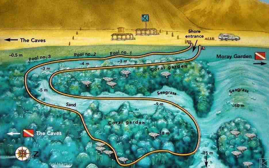
Three Pools
28°26.267′ N · 34°27.450′ E · 10 km south of Dahab
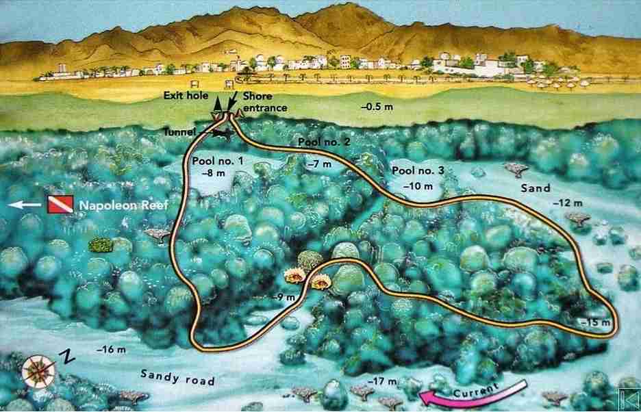
Also the friendliest of the Dahab local dive sites for newer divers. It sits in Wadi Qnai, ten kilometres south of Dahab and three hundred metres south of Moray Garden, where a large signboard in front of a small Bedouin restaurant marks the entry. Its name comes from three real pools in the reef plate, each with a sandy floor three to four metres deep, lined up one behind the other.
Start on a high tide, because moving between the pools is far easier then. After the third and largest one you exit into open water. Outside, a hard coral slope carries massive porites, small pinnacles, salad corals and brain corals. Drop to fifteen or twenty metres and swing a wide anticlockwise circle with the reef on your left.
Watch for
- Firstly Red Sea Moses sole, half-buried in the sand of the last pool
- Then blackspotted pufferfish in the shallows
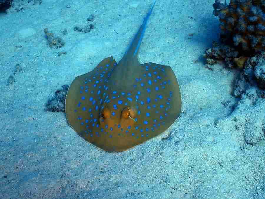
- Also bluespotted ribbontail rays (Taeniura lymma) on the open sand
- Also anemones with their anemonefish across the garden
- Meanwhile butterflyfish, bluespine unicornfish and parrotfish
- Finally blue triggerfish patrolling the coral
Extend it. When conditions allow, carry on north from here and finish the dive at Moray Garden instead of turning back. That turns a short shallow dive into the best value entry on this coast.
The Caves
28°25.000′ N · 34°27.364′ E
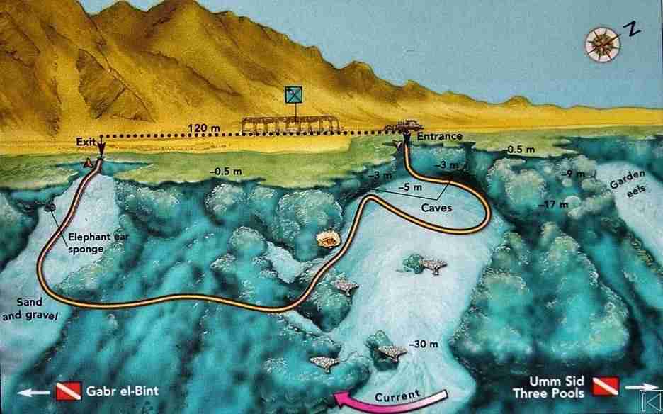
Finally the last of the Dahab local dive sites before Gabr el Bint, two point two kilometres south of Three Pools. Nothing marks the entry except a small Bedouin restaurant and a crack in the reef plate.
Normally this is dived as a drift, exiting a hundred and twenty metres south where a small bay opens in the reef. Descend the gravel slope and, at three metres, two caves appear. Those caves are the whole point of the site. The southern one, immediately to your right, deserves the time: soft corals, sponges and black corals line it. Afterwards drop to sixteen or twenty-two metres, keep the reef on your right and run south to the exit bay.
Watch for
- Firstly the two caves at three metres, open and bright rather than enclosed
- Then the soft corals, sponges and black coral lining the southern one
- Also the exit bay, since missing it means a long swim back
- Finally Umm Sid, 470 m north at 28°25.654′ N, 34°27.352′ E
Choosing between the Dahab local dive sites
For wilderness
Namely Ras Abu Galum, reached on foot or by camel. Also the only one that needs a whole day rather than a morning.
For coral structure
Islands and its porites labyrinth. Because the site is shallow, bottom time is effectively unlimited.
For an easy morning
Three Pools, with its sandy floors at three to four metres. Certainly the friendliest entry for a newer diver.
For something different
The Caves, dived as a drift. Meanwhile the two caves themselves sit at three metres and stay bright throughout.
For big fish
Napoleon Reef, by boat. Notably the only site here that is not entered from the beach.
For a quiet dive
Ras Abu Helal and its buttress. Above all, check the current at the tip before committing to a direction.
Conditions and access at the Dahab local dive sites
Water
- Firstly visibility, generally 20 to 30 m and best early in the day
- Then temperature: 21 to 22°C in winter, 25 to 27°C in summer
- Also current, mild everywhere except the tip at Ras Abu Helal
- Finally exposure: a 5 mm suit works, and a hood helps in winter
Getting in
- Firstly from shore at five of the six Dahab local dive sites
- Then by boat or zodiac at Napoleon Reef, 450 m offshore
- Also by camel or 4×4 at Ras Abu Galum, ninety minutes either way
- Finally at high water anywhere a reef platform must be crossed
Practical notes
- Firstly check the tide for Islands, Three Pools and the Caves
- Then carry booties, since entries cross rock, gravel and reef plate
- Also treat Ras Abu Galum as a full day rather than a morning
- Meanwhile remember Napoleon Reef needs a boat or a zodiac
- Consequently book a guide for a first visit: several entries are unmarked
- Carry water and shade for the northern and southern ends of the coast
- Also budget for park fees inside the protected area
- Finally take every piece of rubbish back out with you
Level. Open water with a guide covers everything on this page. Nothing here goes past twenty-two metres, so the demands are entry, navigation and tide rather than depth.
Planning your Dahab local dive sites trip
Generally these six sites fill three or four diving days comfortably. Above all, put Ras Abu Galum on its own day, because the journey each way eats the morning and the afternoon around it.
Meanwhile Islands, Napoleon Reef and Three Pools sit close enough together to pair up, and the Caves runs best as a drift on a calm afternoon. Consequently the tide table decides the order more than anything else does.
Useful links
- The whole coast, north and south — every region around the town in one guide.
- Eel Gardens, Golden Blocks and Lighthouse — the three easy beach entries around Assalah.
- The Canyon — the deep fissure and its glassfish cave.
- The Blue Hole — the 120 m sinkhole, the Bells and the Arch.
- Gabr el Bint — the wall south of the Caves, by camel or by boat.
- Safety standards and emergency care — briefings, oxygen and chamber contacts.
- Red Sea Liveaboard — safari routes and boats across the Egyptian Red Sea.
- Divers Alert Network (DAN) — insurance and emergency guidance.
Frequently asked questions
How do I reach Ras Abu Galum?
On foot or by camel along the coastal path from the Blue Hole, in about ninety minutes. A four-wheel drive can also come down Wadi Rasasa.
Which of the Dahab local dive sites suits beginners best?
Three Pools, thanks to its shallow sandy pools. Islands works well too, provided you enter on a high tide.
Do I need a boat anywhere?
Only at Napoleon Reef, which sits about 450 metres offshore. Everything else on this page is entered from the beach.
Why does high tide keep coming up?
Because several entries cross a wide reef platform. At high water you swim over living coral instead of walking on it.
Are there caves to penetrate at the Caves?
Two small ones at three metres, open and bright rather than enclosed. Both are lined with soft corals, sponges and black coral.
Is there a fee for the protected area?
Yes. Ras Abu Galum has been a Managed Resource Protected Area since 1992, so entry fees apply and rubbish must leave with you.
What are you waiting for?
Book your adventure
Tell us which experience you want to enjoy and leave the rest to us. If you have questions, or you are still choosing between sites, our team will talk it through with you before you commit to anything.
Inquiry