
Diver’s Guide · Red Sea Diving Guide
The Red Sea Conditions, reefs and the checks before you dive
2,300 km long · 2,800 m deep · 4.1% salinity · 40 m visibility
Geologically young, almost landlocked, unusually salty and remarkably clear. That isolation shaped the Red Sea’s reefs, its endemic species and its visibility — and it is what makes planning a dive here different from anywhere else.
What this Red Sea diving guide covers
This Red Sea diving guide covers both halves of the same problem: what the sea does, and what you do about it. The first half is conditions — salinity, visibility, temperature, current, wind. The second is the checks that follow from them, which is where most trips are actually won or lost.
All of it traces back to one fact. This is a long, narrow, almost closed basin in one of the hottest and driest regions on earth. Firstly the evaporation drives the salinity up and changes how much lead you carry. Then the lack of rivers keeps the water clear. Also the narrow shape turns ordinary tide into real current at reef corners. Finally the wind decides more itineraries than anything underwater ever does.
Consequently a diver who understands the basin plans better than one who only reads the forecast, and a diver who has done the weighting check plans better than one who has read about salinity.
In order, on this page
- Firstly where the name came from, and why nobody can prove it
- Then how the basin formed, and why it is still widening
- Also salinity at 4.1%, and the weighting check it forces
- Meanwhile visibility, and the reasons it can still collapse
- Besides those, temperature and honest wetsuit advice
- Then currents and tides, and three ways to read them before you descend
- After that, wind, waves and surge, which govern the surface
- Next, choosing a site that matches your recent experience
- Finally the safety checklist, in the order you actually use it
Seasonal patterns repeat. They do not guarantee. Namely every figure here is a typical value, not a promise. The reef you dived last March can behave completely differently this March, and planning as though it cannot is how people get caught out.
The wind decides, not the water. Consequently a boat can cancel a perfect site in flat visibility because the surface will not allow a safe pickup. That call belongs to the crew, every time.
Where the name comes from
The origin is still debated. The ancient Greeks called it the Erythrean Sea, from erythros, meaning red. Three explanations are usually offered, and none of them has ever been proven.
A direction, not a colour
Namely some ancient civilisations tied colours to compass directions, with red standing for south.
The coastal cliffs
Also rocks rich in iron oxide, which give parts of the coastline a reddish-brown cast in low sun.
Seasonal blooms
Meanwhile blooms of Trichodesmium erythraeum, which can tint areas of surface water reddish-brown.
How the Red Sea was formed
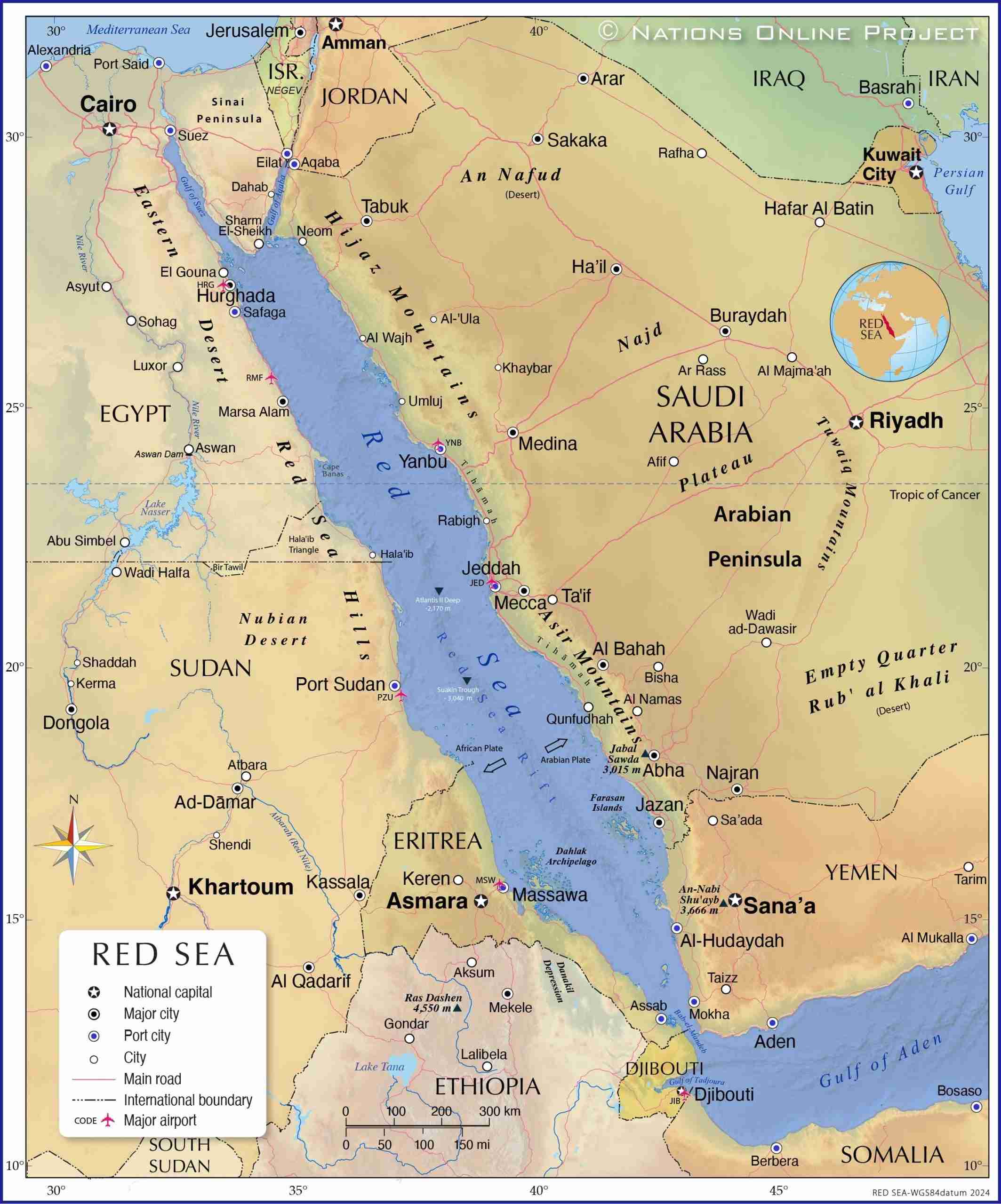
The basin began forming tens of millions of years ago as the African and Arabian tectonic plates separated. The plates are still moving apart, so the sea is still widening, slowly.
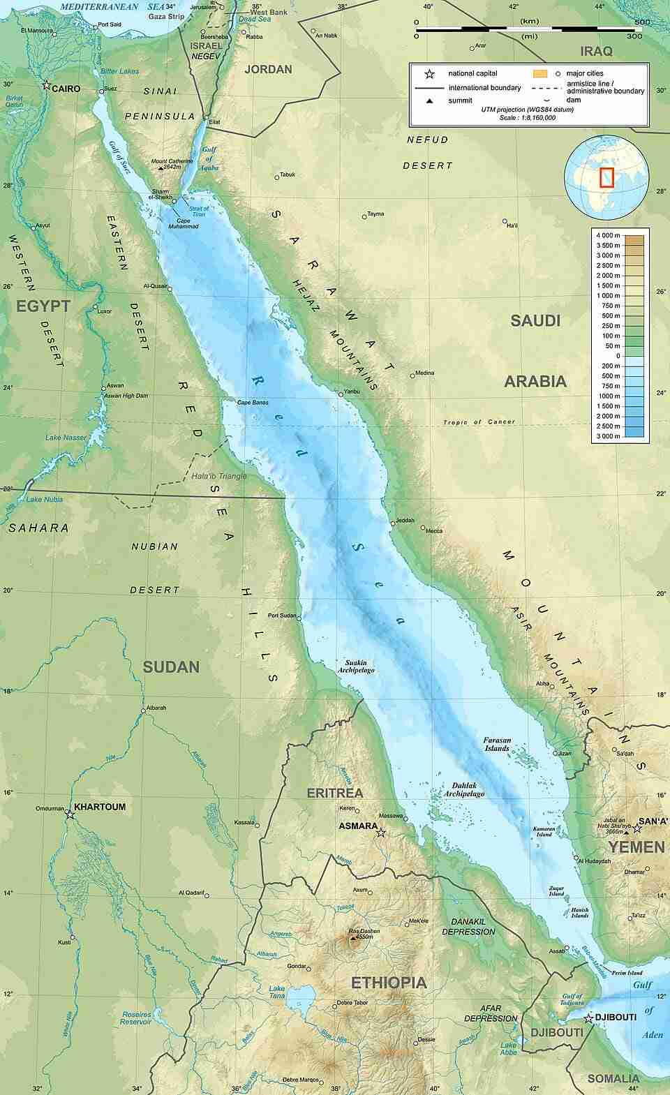
At the southern end it narrows at the Strait of Bab-el-Mandeb, between Yemen and Djibouti. Because that connection is both narrow and shallow, water exchange with the Gulf of Aden and the Indian Ocean is limited. That single constraint is behind most of what follows.
What it meant for marine life
Consequently many species evolved separately from their Indian Ocean relatives, producing a high level of endemism. A Red Sea reef looks familiar and subtly wrong to a diver arriving from the Indo-Pacific, and that is why.
Vertical profile
Salinity and weighting when diving the Red Sea
Strong evaporation and limited exchange make this sea saltier than the open ocean. Salinity commonly sits around 4.1%, though it varies by place and season. For divers that means more buoyancy, so you carry slightly more lead than you would elsewhere.
How much more lead that works out to is personal, and it is settled with a buoyancy check on the first dive of a trip rather than by a rule of thumb. That check is described step by step on the practical page.
Why the salinity varies
The north sits at the end of a long, narrow basin with almost no fresh water entering it, so evaporation concentrates the salt. The far south exchanges water with the Gulf of Aden through Bab-el-Mandeb, which dilutes it slightly.
Season moves the number as well. Summer evaporation drives salinity up; winter brings it down again. The swing is small, but it is enough that a diver moving between the Gulf of Aqaba and the southern parks in the same week can notice the difference in the water.
Visibility, and why it still collapses
The clear water is the reason most people open a Red Sea diving guide in the first place, and it is also the condition that changes fastest.
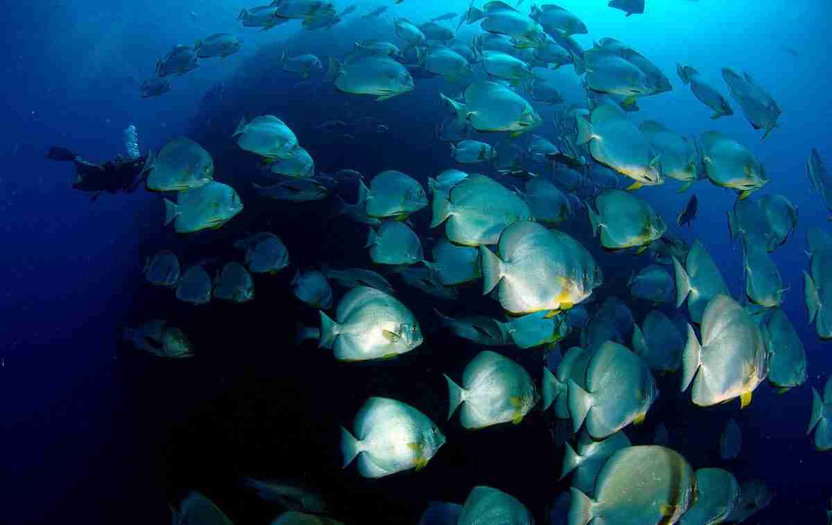
Almost no rivers reach this coastline, so there is very little sediment. Offshore reefs also carry low nutrient levels and limited plankton. Visibility can exceed 40 metres at clean offshore reefs.
However, weather, plankton blooms, stirred sand and current cut it hard, and shallow sites suffer first. Consequently the same reef can give you forty metres one morning and eight the next, with nothing visible on the surface to warn you.
Long sightlines also play a trick worth knowing: distances look shorter than they are. Divers swim further from the boat than they intended because the boat still looks close. Watch the computer and the compass rather than your eyes.
Water temperature and wetsuits
This is the part of the Red Sea diving guide most people get wrong when they pack. Temperature varies by season, latitude and depth. The north is noticeably cooler in winter, whereas Marsa Alam, St John’s and the southern parks stay warmer year round.
| Season | Typical conditions | Suggested exposure protection |
|---|---|---|
| May–October | Warm to very warm water | 3–5 mm, depending on the diver and the dive length |
| November–April, north | Cooler water, stronger wind chill | 5–7 mm; a hood or vest helps |
| November–April, south | Usually warmer than the north | Full 5 mm for most divers |
The water is not what makes you cold. Namely repeated dives, wind on a wet suit and long RIB rides between sites do far more than the thermometer suggests. Consequently a hooded vest earns its space in the bag on any winter trip, even a southern one.
Currents and tides when diving the Red Sea
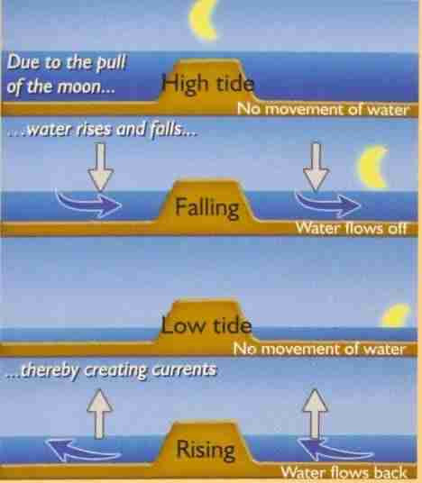
Current here is driven by evaporation, seasonal exchange, local wind, reef shape and tide. Consequently direction can reverse between one side of a reef and the other, and a briefing that describes “the current” as a single thing is describing a guess.
Where it matters most
- Firstly the Gulfs of Suez and Aqaba, where tidal movement is most noticeable
- Then offshore reefs such as Brothers and Daedalus, strong and changeable
- Also narrow channels, where flow accelerates through every gap
- Meanwhile reef corners, where it accelerates around points and walls
- Finally shallow reefs, where current and waves stir sand and kill visibility
What drives it
- Evaporation in the north, which pulls a slow surface flow up the basin
- Seasonal exchange with the Gulf of Aden through Bab-el-Mandeb
- Local wind, which stacks water against a reef and pushes it round the ends
- Reef shape, which turns a mild flow into a fast one at a corner
- Tide, strongest in the two gulfs and through any narrow channel
The current is a condition, not a plan. Reading it before you descend, and knowing what to do if it takes you off the reef, is covered on the practical page.
Climate, wind and waves
Wind is the one condition in this Red Sea diving guide most likely to change your week, because it decides which sites the boat can reach at all.
Climate
The Egyptian coast is hot, dry and sunny. Summer days run extremely warm, while winter mornings and evenings feel cool on an open deck or in a RIB. Rainfall is minimal, but sudden local weather still closes sites.
Wind
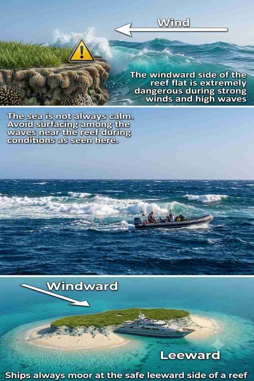
Wind is the single most important factor in planning a trip here. Even with perfect water below, strong wind makes crossings, mooring, RIB work and diver recovery harder or impossible. Offshore sites are far more exposed than coastal reefs, so routes change for safety and not for convenience.
Where waves become a risk
- Firstly entry, where a RIB close to the reef can be pushed onto coral
- Then exit, since re-boarding in a swell is genuinely hard work
- Also surface separation, because waves hide divers and SMBs from the driver
- Finally transfers, which happen on the crew’s word and nobody else’s
Surge
Surge is the back-and-forth movement that surface waves push down into the water. It is strongest in the shallows and against reef walls, which is exactly where the coral is. Hold your buoyancy and keep your distance.
Planning with this Red Sea diving guide
Generally the north suits spring and autumn, the south holds its warmth through winter, and summer is warmest everywhere at the cost of heat on deck. Above all, book the season for the conditions you want rather than the dates that are cheap.
Build slack into any offshore itinerary. A week with no spare day loses its best site to one windy morning, and no crew can fix that afterwards.
Useful links
- The whole Dahab coast — every region around the town in one guide.
- Ras Abu Galum to the Caves — six entries north and south of the bay.
- Eel Gardens, Golden Blocks and Lighthouse — the three easy beach entries around Assalah.
- The Blue Hole — the 120 m sinkhole, the Bells and the Arch.
- The Canyon — the deep fissure and its glassfish cave.
- Gabr el Bint — the wall in the far south, by camel or by boat.
- Safety standards and emergency care — briefings, oxygen and chamber contacts.
- Talk to our team — about the right route for your certification and recent experience.
- Red Sea Liveaboard — safari routes and boats across the Egyptian Red Sea.
- Divers Alert Network (DAN) — insurance and emergency guidance.
- PADI — recreational training standards and certification levels.
Frequently asked questions
Why is the Red Sea called red?
Nobody knows for certain. The theories connect the name to ancient colour directions, to reddish coastal rock, or to seasonal blooms of Trichodesmium. None has ever been proven.
How salty is the Red Sea?
Around 4.1% on average, against roughly 3.5% in the open ocean. Heavy evaporation and almost no fresh water entering the basin concentrate the salt, and the north is saltier than the far south.
What water temperature should I expect?
Warm year round, but the north is noticeably cooler in winter. A full 5 mm works for most divers, with a thicker suit or hood in the colder months.
Why is the visibility so good?
No large river reaches most of this coastline, so almost no sediment enters the water, and offshore reefs carry little plankton. Forty metres is common at clean offshore sites, though wind, plankton blooms, stirred sand and current all cut it.
How deep does the Red Sea get?
Past 2,800 metres in the central trench, where the African and Arabian plates are still pulling apart. Recreational diving happens in the top 30 metres of that, on the reef shelf.
Does wind stop the diving?
It changes it more often than it stops it. Coastal reefs and sheltered leeward sides stay divable in wind that closes the exposed offshore reefs, so a windy week usually means a different route rather than no diving.
When is the best time to dive the Red Sea?
Diving runs year round. Summer gives the warmest water, spring and autumn the most comfortable air, and the south holds its warmth through winter. Offshore itineraries always depend on the wind.
What are you waiting for?
Book your adventure
Tell us which experience you want to enjoy and leave the rest to us. If you are still choosing a season, or not sure which route suits your certification, our team will talk it through with you before you commit to anything.
Inquiry